1970s Maps of Sylvania, Georgia
Explore 4 historic maps of Sylvania from the 1970s. These maps offer a rare glimpse into what life looked like during the 1970s — showing old roads, neighborhoods, homes, and landmarks that have changed or disappeared over time.
Whether you're researching your family's past, planning a metal detecting trip, or studying how Sylvania's landscape evolved across the 1970s, these high-resolution maps are a powerful tool for exploring the history of this region.
- Focus on a specific era: All maps on this page are from the 1970s, giving you a focused view of this time period.
- See what’s changed: Compare century-old streets, trails, and buildings to today's modern landscape using overlays and satellite layers.
- Research with precision: Use these maps for genealogy, historical research, land use analysis, or educational projects.
- View, download, or print: Maps are fully viewable online in high resolution, and can be downloaded or printed for your own records.
Start exploring Sylvania's history through authentic maps from the 1970s. This is your window into the past.
Sylvania, GA maps
(4)- 1978 Map of Sylvania North
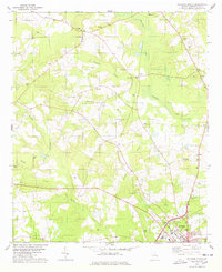 1978 Sylvania North1978 Print · USGSScreven County is depicted here in the late seventies, showing a landscape of timber and tobacco farms centered around Hilltonia. Genealogists can trace family names through numerous local landmarks like Rock Hill Ch, Bascom Cem, and Waters Grove Ch.
 - 1978 Map of Sylvania South
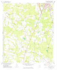 1978 Sylvania South1978 Print · USGSScreven County in the late seventies showcases the expansion of Sylvania and its rural hinterlands along the Central of Georgia line. Genealogists can trace family landmarks and local institutions like the Arnett Sch and Double Heads Ch.
 - 1978 Map of Hunters
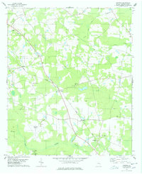 1978 Hunters1978 Print · USGSScreven County's rural landscape is captured here in the late 1970s, centered on the Central of Georgia rail line. Genealogists and historians can trace community roots through numerous landmarks like White Hill, Green Hill Ch, and the Plantation Airpark.
 - 1978 Map of Jacksonboro Bridge
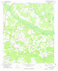 1978 Jacksonboro Bridge1978 Print · USGSScreven County's river-fed lowlands are captured here in the late seventies, showing a landscape defined by Brier Creek and isolated rural settlements. Researchers can trace family sites like the Reddick Cems or locate historic river access points at Kittles Landing and Jacobsons Landing.
End of results
Showing maps 1-4 of 4
Top cities near Sylvania
- Sardis historical maps
- Hiltonia historical maps
- Newington historical maps
- Oliver historical maps
- Rocky Ford historical maps
Frequently asked questions
- What are the different types of historical maps available for Sylvania?
- What is the oldest map of Sylvania?
- Where can I purchase historical maps of Sylvania for my home or office?
- Where can I download high-res historical maps of Sylvania?
- Are there historical topographic maps available for Sylvania?
- Is there historical aerial imagery available for Sylvania?
- Where are historical maps of Sylvania sourced from?