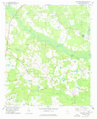
1978 Map of Jacksonboro Bridge
USGS Topo · Published 1978About this map
Brier Creek meanders through the wetlands of northern Screven County, defining a landscape of river landings and scattered rural parishes during the late 1970s. The survey illustrates a settlement pattern rooted in small community centers, often anchored by local houses of worship such as Lawton Grove Ch and Wesley Anna Ch. Along the waterways, points like Kittles Landing and Jacobsons Landing mark the historical intersection of river access and land transport near the namesake Jacksonboro Bridge.
Find a feature on this map
22 named features on this map. Tap any name to fly to it.
Don’t see what you’re looking for? This feature index may not catch every label — zoom into the map to look around manually.
Map Details
Editions of this 1978 Jacksonboro Bridge Map
This is the sole edition of this map. No revisions or reprints were ever made.
Other maps of this area

1918 · Oliver
USGS Topo · 1:62,500

1919 · Shirley
USGS Topo · 1:62,500

1920 · Hilltonia
USGS Topo · 1:62,500

1920 · Oliver
USGS Topo · 1:62,500

1920 · Peeples
USGS Topo · 1:62,500

1943 · Hilltonia
USGS Topo · 1:62,500

1943 · Peeples
USGS Topo · 1:62,500

1943 · Shirley
USGS Topo · 1:62,500

1943 · Millen
USGS Topo · 1:125,000

1943 · Oliver
USGS Topo · 1:62,500