1940s Maps of Tattnall County, Georgia
Explore 6 historic maps of Tattnall County from the 1940s. These maps offer a rare glimpse into what life looked like during the 1940s — showing old roads, neighborhoods, homes, and landmarks that have changed or disappeared over time.
Whether you're researching your family's past, planning a metal detecting trip, or studying how Tattnall County's landscape evolved across the 1940s, these high-resolution maps are a powerful tool for exploring the history of this region.
- Focus on a specific era: All maps on this page are from the 1940s, giving you a focused view of this time period.
- See what’s changed: Compare century-old streets, trails, and buildings to today's modern landscape using overlays and satellite layers.
- Research with precision: Use these maps for genealogy, historical research, land use analysis, or educational projects.
- View, download, or print: Maps are fully viewable online in high resolution, and can be downloaded or printed for your own records.
Start exploring Tattnall County's history through authentic maps from the 1940s. This is your window into the past.
Tattnall County, GA maps
(6)- 1944 Map of Claxton
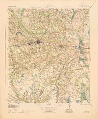 1944 Claxton1944 Print · USGSSoutheast Georgia was undergoing significant change in the 1940s as military expansion met established rail towns and rural school districts. Genealogists and historians can trace the footprint of Camp Stewart alongside family-named landmarks like Beasley Sch, Moodys Crossing, and Brewton Mill Sch.
 - 1944 Map of Glennville
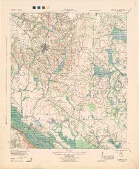 1944 Glennville1944 Print · USGSGlennville and the surrounding Georgia coastal plain are captured during the mid-1940s, showing a landscape defined by small farming communities and river commerce. Genealogists can trace family footprints through numerous local landmarks like Howard Chapel, Mendes, and the Rye Patch School.
 - 1946 Map of Brunswick, 1948 Print
 1946 Brunswick1948 Print · USGSCoastal Georgia in the mid-forties reveals a landscape defined by the Camp Stewart Military Reservation and the sprawling barrier islands. Genealogists and historians can trace the rail-and-river network through inland towns like Ludowici and Jesup, or locate coastal landmarks like the St Simon Light.
 - 1947 Map of Savannah
 1947 Savannah1947 Print · USGSCoastal Georgia and South Carolina are captured here in the mid-forties, showing the rail-and-river networks of the Lowcountry. Genealogists and researchers can trace old crossroads and river towns from Statesboro to Beaufort, alongside military sites like Camp Stewart and Parris Island.
 - 1948 Map of Brunswick
 1948 Brunswick1948 Print · USGSCoastal Georgia in the late 1940s is defined here by its labyrinthine barrier islands and the massive footprint of Camp Stewart. Genealogists and historians can trace the rail-tied growth of Jesup and Hinesville or locate coastal landmarks like St Simon Light.
 - 1948 Map of Savannah
 1948 Savannah1948 Print · USGSThe Georgia and South Carolina Lowcountry comes alive in this post-war survey of the coast and its river-fed hinterlands. Genealogists and historians can trace rail lines like the Central of Georgia RR and find established settlements such as Isle of Hope and Sylvania.
End of results
Showing maps 1-6 of 6
Top cities of Tattnall County
- Glennville historical maps
- Reidsville historical maps
- Collins historical maps
- Cobbtown historical maps
- Manassas historical maps
Frequently asked questions
- What are the different types of historical maps available for Tattnall County?
- What is the oldest map of Tattnall County?
- Where can I purchase historical maps of Tattnall County for my home or office?
- Where can I download high-res historical maps of Tattnall County?
- Are there historical topographic maps available for Tattnall County?
- Is there historical aerial imagery available for Tattnall County?
- Where are historical maps of Tattnall County sourced from?