1970s Maps of Chickasawhatchee, Georgia
Explore 2 historic maps of Chickasawhatchee from the 1970s. These maps offer a rare glimpse into what life looked like during the 1970s — showing old roads, neighborhoods, homes, and landmarks that have changed or disappeared over time.
Whether you're researching your family's past, planning a metal detecting trip, or studying how Chickasawhatchee's landscape evolved across the 1970s, these high-resolution maps are a powerful tool for exploring the history of this region.
- Focus on a specific era: All maps on this page are from the 1970s, giving you a focused view of this time period.
- See what’s changed: Compare century-old streets, trails, and buildings to today's modern landscape using overlays and satellite layers.
- Research with precision: Use these maps for genealogy, historical research, land use analysis, or educational projects.
- View, download, or print: Maps are fully viewable online in high resolution, and can be downloaded or printed for your own records.
Start exploring Chickasawhatchee's history through authentic maps from the 1970s. This is your window into the past.
Chickasawhatchee, GA maps
(2)- 1973 Map of Chickasawhatchee, 1974 Print
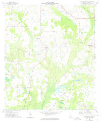 1973 Chickasawhatchee1974 Print · USGSTerrell County's agricultural heartland is documented here in the early seventies, centered on rural communities and the headwaters of the Chickasawhatchee. Genealogists can trace family roots through numerous local landmarks like Clarks Mill, the Andrew Jackson Monument, and New Hope Cem.
 - 1973 Map of Sasser, 1974 Print
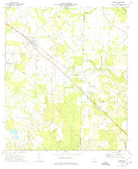 1973 Sasser1974 Print · USGSTerrell and Lee Counties appear in the early 1970s as a landscape of rural settlements and rail-line hubs. Genealogists and historians can trace family roots through sites like Macedonia Ch, Huckby Cem, and the old rail stop at Sasser.2 unique versions available
End of results
Showing maps 1-2 of 2
Top cities near Chickasawhatchee
- Albany historical maps
- Dawson historical maps
- Putney historical maps
- Leesburg historical maps
- Morgan historical maps
- Shellman historical maps
See more
Frequently asked questions
- What are the different types of historical maps available for Chickasawhatchee?
- What is the oldest map of Chickasawhatchee?
- Where can I purchase historical maps of Chickasawhatchee for my home or office?
- Where can I download high-res historical maps of Chickasawhatchee?
- Are there historical topographic maps available for Chickasawhatchee?
- Is there historical aerial imagery available for Chickasawhatchee?
- Where are historical maps of Chickasawhatchee sourced from?