1940s Maps of LaFayette, Georgia
Explore 3 historic maps of LaFayette from the 1940s. These maps offer a rare glimpse into what life looked like during the 1940s — showing old roads, neighborhoods, homes, and landmarks that have changed or disappeared over time.
Whether you're researching your family's past, planning a metal detecting trip, or studying how LaFayette's landscape evolved across the 1940s, these high-resolution maps are a powerful tool for exploring the history of this region.
- Focus on a specific era: All maps on this page are from the 1940s, giving you a focused view of this time period.
- See what’s changed: Compare century-old streets, trails, and buildings to today's modern landscape using overlays and satellite layers.
- Research with precision: Use these maps for genealogy, historical research, land use analysis, or educational projects.
- View, download, or print: Maps are fully viewable online in high resolution, and can be downloaded or printed for your own records.
Start exploring LaFayette's history through authentic maps from the 1940s. This is your window into the past.
LaFayette, GA maps
(3)- 1946 Map of Kensington, 1947 Print
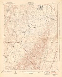 1946 Kensington1947 Print · USGSWalker County during the mid-forties is captured here as a landscape of ridge-top vistas and rail-connected valley towns. Genealogists and researchers can locate family sites like Owings Cem, the Gordon Lee School, and the old works at Hall Mill.6 unique versions available
 - 1946 Map of Estelle, 1960 Print
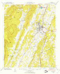 1946 Estelle1960 Print · USGSWalker County during the mid-forties reveals a settled landscape where the industrial corridor of the Central of Georgia meets the base of Pigeon Mountain. Researchers can trace local heritage through landmarks like the County Farm, Blaylock Mill, and the Log Cabin Tabernacle.3 unique versions available
 - 1947 Map of Estelle, 1948 Print
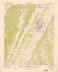 1947 Estelle1948 Print · USGSWalker County, Georgia, is captured here in the late 1940s as the rail-and-road network around La Fayette reached its mid-century peak. Researchers can trace ancestral locations at the County Farm, Blaylock Mill, or rural schools like Fairview Sch.2 unique versions available
End of results
Showing maps 1-3 of 3
Top cities near LaFayette
- Fort Oglethorpe historical maps
- Summerville historical maps
- Ringgold historical maps
- Chickamauga historical maps
- Trenton historical maps
- Trion historical maps
See more
Top neighborhoods of LaFayette
- Pledger Parkway historical maps
- Winwood Forest historical maps
- Dogwood Circle historical maps
- Meadowview historical maps
- Oak Park historical maps
- Linwood historical maps
See more
Frequently asked questions
- What are the different types of historical maps available for LaFayette?
- What is the oldest map of LaFayette?
- Where can I purchase historical maps of LaFayette for my home or office?
- Where can I download high-res historical maps of LaFayette?
- Are there historical topographic maps available for LaFayette?
- Is there historical aerial imagery available for LaFayette?
- Where are historical maps of LaFayette sourced from?