1980s Maps of LaFayette, Georgia
Explore 3 historic maps of LaFayette from the 1980s. These maps offer a rare glimpse into what life looked like during the 1980s — showing old roads, neighborhoods, homes, and landmarks that have changed or disappeared over time.
Whether you're researching your family's past, planning a metal detecting trip, or studying how LaFayette's landscape evolved across the 1980s, these high-resolution maps are a powerful tool for exploring the history of this region.
- Focus on a specific era: All maps on this page are from the 1980s, giving you a focused view of this time period.
- See what’s changed: Compare century-old streets, trails, and buildings to today's modern landscape using overlays and satellite layers.
- Research with precision: Use these maps for genealogy, historical research, land use analysis, or educational projects.
- View, download, or print: Maps are fully viewable online in high resolution, and can be downloaded or printed for your own records.
Start exploring LaFayette's history through authentic maps from the 1980s. This is your window into the past.
LaFayette, GA maps
(3)- 1981 Map of Chickamauga, 1982 Print
 1981 Chickamauga1982 Print · USGSThe tri-state border region of Georgia, Alabama, and Tennessee comes into focus during the early eighties, defined by the towering ridges of the Appalachians. Historians can trace the preserved grounds of Chickamauga and Chattanooga National Military Park and old rail stops like Rising Fawn or Sulphur Springs.2 unique versions available
 - 1983 Map of Lafayette
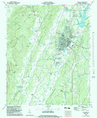 1983 Lafayette1983 Print · USGSWalker County during the early eighties shows a landscape shaped by the Central of Georgia railroad and the rugged ridges of Pigeon Mountain. Genealogists and researchers can locate family sites at Caldwell Cem, trace the karst geography of Ellison Cave, and see early industrial footprints like the Barwick-Lafayette Airport.
 - 1983 Map of Kensington, 1984 Print
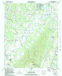 1983 Kensington1984 Print · USGSWalker County in the early eighties was a landscape of deep valleys and rising ridges shaped by the Central of Georgia rail line. Genealogists can trace family landmarks and rural roots at District Hill Cemetery, Pond Springs School, and the community of Chickamauga.
End of results
Showing maps 1-3 of 3
Top cities near LaFayette
- Fort Oglethorpe historical maps
- Summerville historical maps
- Ringgold historical maps
- Chickamauga historical maps
- Trenton historical maps
- Trion historical maps
See more
Top neighborhoods of LaFayette
- Pledger Parkway historical maps
- Winwood Forest historical maps
- Dogwood Circle historical maps
- Meadowview historical maps
- Oak Park historical maps
- Linwood historical maps
See more
Frequently asked questions
- What are the different types of historical maps available for LaFayette?
- What is the oldest map of LaFayette?
- Where can I purchase historical maps of LaFayette for my home or office?
- Where can I download high-res historical maps of LaFayette?
- Are there historical topographic maps available for LaFayette?
- Is there historical aerial imagery available for LaFayette?
- Where are historical maps of LaFayette sourced from?