1900s (20th Century) Maps of Toomsboro, Georgia
Explore 8 historic maps of Toomsboro from the 1900s (20th Century). These maps offer a rare glimpse into what life looked like during the 1900s — showing old roads, neighborhoods, homes, and landmarks that have changed or disappeared over time.
Whether you're researching your family's past, planning a metal detecting trip, or studying how Toomsboro's landscape evolved across the 1900s, these high-resolution maps are a powerful tool for exploring the history of this region.
- Focus on a specific era: All maps on this page are from the 1900s, giving you a focused view of this time period.
- See what’s changed: Compare century-old streets, trails, and buildings to today's modern landscape using overlays and satellite layers.
- Research with precision: Use these maps for genealogy, historical research, land use analysis, or educational projects.
- View, download, or print: Maps are fully viewable online in high resolution, and can be downloaded or printed for your own records.
Start exploring Toomsboro's history through authentic maps from the 1900s. This is your window into the past.
Toomsboro, GA maps
(8)- 1916 Map of Irwinton, 1963 Print
 1916 Irwinton1963 Print · USGSWilkinson County is captured here in the years before the Great War, showing a network of rural settlements connected by the Central of Georgia railroad. Genealogists can trace family landmarks and community centers like Goldens Mill, Hazelino School, and Toomsboro.2 unique versions available
 - 1920 Map of Irwinton
 1920 Irwinton1920 Print · USGSWilkinson County in the years following the Great War reveals a landscape of scattered rural hamlets and river-bottom agriculture. Researchers can trace the lineage of local landmarks like Goldens Mill, Myrtle Spring Church, and the winding Oconee River corridor.2 unique versions available
 - 1957 Map of Macon
 1957 Macon1957 Print · USGSMid-century Georgia comes into focus as the river-and-rail economy shifts toward a new era of aviation and highway travel. Trace family roots and vanished landmarks across the Ocmulgee River valley from Macon to the onion fields of Vidalia.
 - 1958 Map of Macon
 1958 Macon1958 Print · USGSMiddle Georgia during the late fifties shows the post-war expansion of Warner Robins alongside the deep-rooted rail hubs of the Central of Georgia line. Researchers can trace the river-bound boundaries of numerous counties and find local landmarks like Veterans Memorial Hospital and Robins AFB.
 - 1964 Map of Macon
 1964 Macon1964 Print · USGSCentral Georgia in the mid-sixties is defined by its major river valleys and a booming military presence. Genealogists and historians can trace the growth of Warner Robins near Robins AFB or locate smaller rural junctions like Allentown and Jeffersonville along the historic Southern railroad lines.2 unique versions available
 - 1973 Map of Toomsboro, 1977 Print
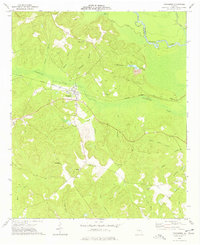 1973 Toomsboro1977 Print · USGSToomsboro was a critical junction of the Central of Georgia railroad and rural bypasses in the early 1970s. Genealogists and local historians can trace family roots through several legacy sites, including Ebenezer Church, Lords Cemetery, and Beech Hill.
 - 1978 Map of Macon, 1980 Print
 1978 Macon1980 Print · USGSCentral Georgia during the late seventies reveals a landscape shaped by military expansion and clay mining. Genealogists and local historians can trace the development of Warner Robins, the grounds of Wesleyan College, and the rural surroundings of Griswoldville.2 unique versions available
 - 1988 Map of Macon, 1989 Print
 1988 Macon1989 Print · USGSCentral Georgia is captured during the late eighties, showing the expansive river systems and growing urban hubs of the regional interior. Genealogists and historians can trace the paths of the Central of Georgia Railroad and locate communities like Warner Robbins, Dublin, and Sandersville.
End of results
Showing maps 1-8 of 8
Top cities near Toomsboro
- Milledgeville historical maps
- Dublin historical maps
- Sandersville historical maps
- Gordon historical maps
- Ivey historical maps
- McIntyre historical maps
See more
Frequently asked questions
- What are the different types of historical maps available for Toomsboro?
- What is the oldest map of Toomsboro?
- Where can I purchase historical maps of Toomsboro for my home or office?
- Where can I download high-res historical maps of Toomsboro?
- Are there historical topographic maps available for Toomsboro?
- Is there historical aerial imagery available for Toomsboro?
- Where are historical maps of Toomsboro sourced from?