
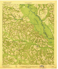
1920 Map of Irwinton
USGS Topo · Published 1920About this map
Irwinton serves as the focal point of this central Georgia landscape, situated south of the Commissioners Creek drainage basin. The area's early 20th-century character is defined by a dense network of rural infrastructure, including numerous family-named landmarks like Bloodworths Store, Stubbs Store, and the industrial site at Goldens Mill. The eastern boundary is dominated by the meandering Oconee River, which created a complex system of oxbows and backwaters such as Slab Lake, Lords Lake, and Peachtree Lake.
Find a feature on this map
103 named features on this map. Tap any name to fly to it.
Don’t see what you’re looking for? This feature index may not catch every label — zoom into the map to look around manually.
Map Details
Editions of this 1920 Irwinton Map
2 editions found
Other maps of this area

1912 · Milledgeville
USGS Topo · 1:62,500

1916 · Irwinton
USGS Topo · 1:62,500

1953 · Athens
USGS Topo · 1:250,000

1956 · Gordon
USGS Topo · 1:62,500

1956 · Jeffersonville
USGS Topo · 1:62,500

1957 · Macon
USGS Topo · 1:250,000

1958 · Macon
USGS Topo · 1:250,000

1958 · Athens
USGS Topo · 1:250,000

1959 · Athens
USGS Topo · 1:250,000

1961 · Deepstep
USGS Topo · 1:24,000