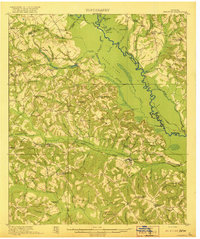
1920 Map of Irwinton
USGS Topo · Published 1920About this map
Irwinton serves as the focal point of this 1916 survey, situated among a dense network of early 20th-century Georgia schools and churches. The landscape is defined by the winding Oconee River and the high ground of Beech Ridge, which separates the river's swampy basin from the upland agricultural areas. Transportation and commerce center on the Central of Georgia railroad, connecting the settlements of McIntyre and Toomsboro.
Find a feature on this map
91 named features on this map. Tap any name to fly to it.
Don’t see what you’re looking for? This feature index may not catch every label — zoom into the map to look around manually.
Map Details
Editions of this 1920 Irwinton Map
2 editions found
Other maps of this area

1912 · Milledgeville
USGS Topo · 1:62,500

1916 · Irwinton
USGS Topo · 1:62,500

1920 · Irwinton
USGS Topo · 1:62,500

1953 · Athens
USGS Topo · 1:250,000

1956 · Gordon
USGS Topo · 1:62,500

1956 · Jeffersonville
USGS Topo · 1:62,500

1957 · Macon
USGS Topo · 1:250,000

1958 · Macon
USGS Topo · 1:250,000

1958 · Athens
USGS Topo · 1:250,000

1959 · Athens
USGS Topo · 1:250,000