Old Maps of Kaʻilikiʻi, Hawaii for Genealogy
Trace your family roots with 13 historic maps of Kaʻilikiʻi. These high-res maps reveal old neighborhoods, homesites, landmarks, and streets — helping you uncover where your ancestors lived and how the area evolved over time.
- Explore historic neighborhoods: Identify where your relatives may have lived in the 1800s or 1900s.
- Compare maps over time: Trace the changes in streets, buildings, and landmarks for multi-generational research.
- Perfect for genealogy & ancestry research: Used by family historians and researchers to map out lineage and migration.
These maps are an incredible resource for exploring your personal connection to Kaʻilikiʻi's past.
Kaʻilikiʻi, HI maps
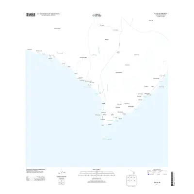
(13)- 1924 Map of Kalae
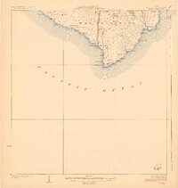 1924 Kalae1924 Print · USGSThe southern tip of the Big Island in the 1920s shows a landscape of recent lava flows and sacred Hawaiian sites. Researchers can trace the Lava Flow of 1887, identify the Kamaoa Homesteads, and locate ancient temples like Ka Heiau o Kalalea.3 unique versions available
 - 1954 Map of Hawaii South
 1954 Hawaii South1954 Print · USGSThe southern reaches of the Big Island in the mid-fifties show a landscape of volcanic peaks, coastal villages, and upland timber mills. Researchers can trace the old island infrastructure through sites like Koa Mill, Hoopuloa, and the remote Mountain House.
 - 1959 Map of Hawaii South
 1959 Hawaii South1959 Print · USGSThe southern half of the Big Island appears here in the late fifties, dominated by the active volcanic peaks and extensive forest reserves. Researchers can trace the mid-century footprints of Pahala, Waiohinu, and the agricultural grounds of Gaspard Dairy.
 - 1961 Map of Hawaii South
 1961 Hawaii South1961 Print · USGSThe southern region of the Big Island appears here in the early sixties, illustrating a landscape of volcanic craters and remote agricultural outposts. Genealogists and historians can trace the locations of Wood Valley Camp, the Koa Mill, and the ruins at Kahio.
 - 1962 Map of Hawaii South
 1962 Hawaii South1962 Print · USGSThe southern half of Hawaii Island in the early sixties showcases a landscape defined by volcanic rifts and coastal settlements. Researchers can trace the Hawaii Consolidated rail line, find the Kuee (Ruined) site, and locate remote camps like Hooper Camp.2 unique versions available
 - 1962 Map of Ka Lae, 1964 Print
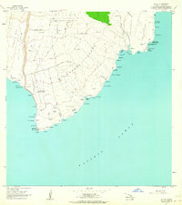 1962 Ka Lae1964 Print · USGSThe southern tip of Hawaii Island comes into focus in the early sixties, showing a landscape where ancient culture meets Cold War technology. Researchers can trace land divisions in Kamaoa Homesteads or locate historical sites like Heiau o Kalalea and the Astronomic Station.2 unique versions available
 - 1975 Map of Hawaii, 1977 Print
 1975 Hawaii1977 Print · USGSThe Big Island in the mid-seventies is captured here as a landscape of volcanic giants and coastal sugar communities. Genealogists and historians can locate former plantation sites like Pepeekeo Mill or trace the routes of the Mamalahoa Highway through Kamuela.
 - 1980 Map of Hawaii County Sheet 3, 1984 Print
 1980 Hawaii County Sheet 31984 Print · USGSThe Big Island's South Kona and Kau districts are captured here in the early 1980s, from the historic coffee lands to the southern tip. Researchers can trace the layout of coastal villages and sugar-era settlements like Milolii, Pahala, and the City of Refuge Nat Historical Pk.
 - 1982 Map of Ka Lae
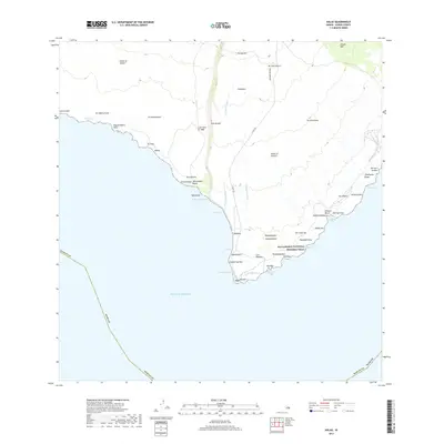
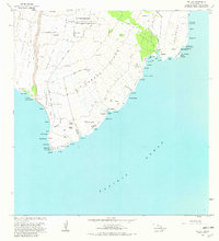 1982 Ka Lae1982 Print · USGSThe southernmost tip of the Big Island is captured in the early eighties, showcasing the intersection of ancient Hawaiian sites and modern infrastructure. Researchers can locate Heiau o Molilele, the Lava Flow of 1868, and the South Point Afs military installation.2 unique versions available
 - 1995 Map of Kalae, 2000 Print
 1995 Kalae2000 Print · USGSThe southern tip of Hawaii in the mid-nineties shows a landscape of volcanic bluffs and historic homesteads. Trace the coastal reaches from the Coast Guard Reservation at Kalae up to the homesteads of Kama'oa.
 - 2013 Map of Kalae, 2013 Print
 2013 Kalae2013 Print · USGSCovers Kaʻilikiʻi, including Hawaiʻi County, United States, and other nearby areas
 - 2017 Map of Kalae, 2017 Print
 2017 Kalae2017 Print · USGSCovers Kaʻilikiʻi, including Hawaiʻi County, United States, and other nearby areas
 - 2024 Map of Kalae, 2024 Print
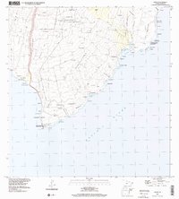
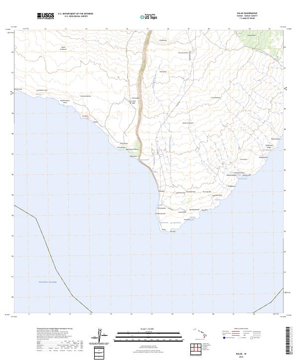 2024 Kalae2024 Print · USGSThe southern tip of the Big Island appears here in its modern topographic context, showing the intersection of volcanic history and coastal geography. Researchers can trace the path of the Lava Flow of 1868 and locate traditional sites like Hāwea and Kalae.
End of results
Showing maps 1-13 of 13
Top cities near Kaʻilikiʻi
Frequently asked questions
- What are the different types of historical maps available for Kaʻilikiʻi?
- What is the oldest map of Kaʻilikiʻi?
- Where can I purchase historical maps of Kaʻilikiʻi for my home or office?
- Where can I download high-res historical maps of Kaʻilikiʻi?
- Are there historical topographic maps available for Kaʻilikiʻi?
- Is there historical aerial imagery available for Kaʻilikiʻi?
- Where are historical maps of Kaʻilikiʻi sourced from?