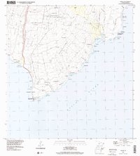
1995 Map of Kalae
USGS Topo · Published 2000About this map
Kalae, the southernmost tip of the Big Island, is the primary focal point of this coastal survey. The landscape is defined by the sharp transition from the volcanic flows to the Pacific Ocean, where names like Wai'ō'ahukini and Kamilo Point mark the interface between land and sea. This 1995 revision reveals a mix of traditional land divisions and modern maritime infrastructure, including an Astronomic Station and the Coast Guard Reservation.
Find a feature on this map
89 named features on this map. Tap any name to fly to it.
Don’t see what you’re looking for? This feature index may not catch every label — zoom into the map to look around manually.
Map Details
Editions of this 1995 Kalae Map
This is the sole edition of this map. No revisions or reprints were ever made.
Other maps of this area

1924 · Kalae
USGS Topo · 1:62,500

1924 · Honuapo
USGS Topo · 1:62,500

1954 · Hawaii South
USGS Topo · 1:250,000

1959 · Hawaii South
USGS Topo · 1:250,000

1961 · Hawaii South
USGS Topo · 1:250,000

1962 · Hawaii South
USGS Topo · 1:250,000

1962 · Puu Hou
USGS Topo · 1:24,000

1962 · Kahuku Ranch
USGS Topo · 1:24,000
1962 · Ka Lae
USGS Topo · 1:24,000
1962 · Naalehu
USGS Topo · 1:24,000