1990s Maps of Honolulu, Hawaii
Explore 4 historic maps of Honolulu from the 1990s. These maps offer a rare glimpse into what life looked like during the 1990s — showing old roads, neighborhoods, homes, and landmarks that have changed or disappeared over time.
Whether you're researching your family's past, planning a metal detecting trip, or studying how Honolulu's landscape evolved across the 1990s, these high-resolution maps are a powerful tool for exploring the history of this region.
- Focus on a specific era: All maps on this page are from the 1990s, giving you a focused view of this time period.
- See what’s changed: Compare century-old streets, trails, and buildings to today's modern landscape using overlays and satellite layers.
- Research with precision: Use these maps for genealogy, historical research, land use analysis, or educational projects.
- View, download, or print: Maps are fully viewable online in high resolution, and can be downloaded or printed for your own records.
Start exploring Honolulu's history through authentic maps from the 1990s. This is your window into the past.
Honolulu, HI maps
(4)- 1998 Map of Kaneohe, 2000 Print
 1998 Kaneohe2000 Print · USGSWindward Oahu at the close of the century reveals a landscape where suburban Kaneohe meets historic coastal homesteads and mountain reserves. Trace local genealogy and land use through the Waiahole Homesteads, Byodo-In Temple, and Pu‘ohala Village.
 - 1998 Map of Honolulu, 2000 Print
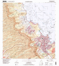
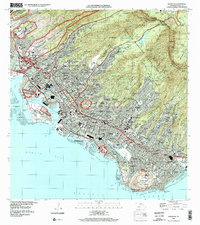 1998 Honolulu2000 Print · USGSHonolulu is captured in the late nineties, showcasing the city's unique geography where volcanic craters like Diamond Head meet a sprawling urban grid. Genealogists and historians can trace institutional landmarks and local neighborhoods from the Royal Mausoleum and Oahu Cemetery to Alewa Heights and Waialae.
 - 1999 Map of Koko Head, 2000 Print
 1999 Koko Head2000 Print · USGSSoutheastern O'ahu shows its modern suburban and conservation character at the end of the millennium. Researchers can trace local development around Hawai'i Kai, the engineering of Kuapa Pond, and protected landmarks like Koko Crater.
 - 1999 Map of Pearl Harbor, 2000 Print
 1999 Pearl Harbor2000 Print · USGSThe southern coast of Oahu appears in remarkable detail at the end of the millennium, showing the dense military and civilian footprint around Pearl Harbor. Researchers can trace the layout of Hickam Air Force Base, find the USS Arizona Memorial, and locate local landmarks like Aloha Stadium.
End of results
Showing maps 1-4 of 4
Top cities near Honolulu
- Waipahu historical maps
- East Honolulu historical maps
- Mililani historical maps
- Pearl City historical maps
- Kailua historical maps
- Kaneohe historical maps
See more
Top neighborhoods of Honolulu
- East Honolulu historical maps
- Kalihi Kai historical maps
- Sand Island historical maps
- Moanalua Gardens historical maps
- Āliamanu historical maps
- Kahala historical maps
See more
Frequently asked questions
- What are the different types of historical maps available for Honolulu?
- What is the oldest map of Honolulu?
- Where can I purchase historical maps of Honolulu for my home or office?
- Where can I download high-res historical maps of Honolulu?
- Are there historical topographic maps available for Honolulu?
- Is there historical aerial imagery available for Honolulu?
- Where are historical maps of Honolulu sourced from?