1960s Maps of Kalaheo, Hawaii
Explore 2 historic maps of Kalaheo from the 1960s. These maps offer a rare glimpse into what life looked like during the 1960s — showing old roads, neighborhoods, homes, and landmarks that have changed or disappeared over time.
Whether you're researching your family's past, planning a metal detecting trip, or studying how Kalaheo's landscape evolved across the 1960s, these high-resolution maps are a powerful tool for exploring the history of this region.
- Focus on a specific era: All maps on this page are from the 1960s, giving you a focused view of this time period.
- See what’s changed: Compare century-old streets, trails, and buildings to today's modern landscape using overlays and satellite layers.
- Research with precision: Use these maps for genealogy, historical research, land use analysis, or educational projects.
- View, download, or print: Maps are fully viewable online in high resolution, and can be downloaded or printed for your own records.
Start exploring Kalaheo's history through authentic maps from the 1960s. This is your window into the past.
Kalaheo, HI maps
(2)- 1963 Map of Koloa, 1965 Print
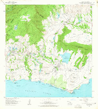 1963 Koloa1965 Print · USGSSouthern Kauai in the early sixties reveals a landscape shaped by sugar and sea, from the plantation heritage of Koloa to the developing shores of Poipu. Researchers can trace old irrigation systems, the Koloa Mill, and historical sites like Nomilo Fishpond.2 unique versions available
 - 1967 Map of Kauai
 1967 Kauai1967 Print · USGSThe Garden Isle and Niihau are shown here in the mid-sixties, capturing the island's transition from plantation roots to a more modern infrastructure. Genealogists can trace family connections in Moloaa Settlement or find coastal landmarks like Nonopapa and Kilauea Point Light.
End of results
Showing maps 1-2 of 2
Top cities near Kalaheo
Frequently asked questions
- What are the different types of historical maps available for Kalaheo?
- What is the oldest map of Kalaheo?
- Where can I purchase historical maps of Kalaheo for my home or office?
- Where can I download high-res historical maps of Kalaheo?
- Are there historical topographic maps available for Kalaheo?
- Is there historical aerial imagery available for Kalaheo?
- Where are historical maps of Kalaheo sourced from?