1970s Maps of Omao, Hawaii
Explore 2 historic maps of Omao from the 1970s. These maps offer a rare glimpse into what life looked like during the 1970s — showing old roads, neighborhoods, homes, and landmarks that have changed or disappeared over time.
Whether you're researching your family's past, planning a metal detecting trip, or studying how Omao's landscape evolved across the 1970s, these high-resolution maps are a powerful tool for exploring the history of this region.
- Focus on a specific era: All maps on this page are from the 1970s, giving you a focused view of this time period.
- See what’s changed: Compare century-old streets, trails, and buildings to today's modern landscape using overlays and satellite layers.
- Research with precision: Use these maps for genealogy, historical research, land use analysis, or educational projects.
- View, download, or print: Maps are fully viewable online in high resolution, and can be downloaded or printed for your own records.
Start exploring Omao's history through authentic maps from the 1970s. This is your window into the past.
Omao, HI maps
(2)- 1970 Map of Kauai, 1974 Print
 1970 Kauai1974 Print · USGSThe islands of Kauai and Niihau are shown during the early 1970s, capturing the balance between military expansion and preserved wilderness. Researchers can trace the layout of Niihau's elusive villages like Puwai or explore Kauai's industrial landscape at Koloa Mill and Port Allen.2 unique versions available
 - 1978 Map of Koloa, 1981 Print
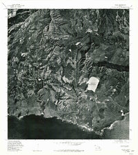 1978 Koloa1981 Print · USGSThe southern coast of Kauai comes into focus in the late seventies as local agriculture and residential growth meet the sea. Researchers can trace the layout of Koloa and Kalaheo while surveying landmarks like Waita Reservoir and Alexander Reservation.
End of results
Showing maps 1-2 of 2
Top cities near Omao
Frequently asked questions
- What are the different types of historical maps available for Omao?
- What is the oldest map of Omao?
- Where can I purchase historical maps of Omao for my home or office?
- Where can I download high-res historical maps of Omao?
- Are there historical topographic maps available for Omao?
- Is there historical aerial imagery available for Omao?
- Where are historical maps of Omao sourced from?