Old Maps of Keomoku Village, Hawaii for Hiking & Exploration
Hike through history with 11 historic maps of Keomoku Village. Explore old trails, ghost towns, and forgotten backroads — perfect for outdoor adventurers and local explorers.
- Rediscover forgotten places: Map out old mining camps, roads, and footpaths that no longer exist on modern maps.
- Layer with modern tools: Combine with LiDAR or satellite views to plan hikes through historical terrain.
- Made for exploration: Popular among hikers, overlanders, and local history lovers.
Use these maps to find adventure and explore the hidden past of Keomoku Village.
Keomoku Village, HI maps
(11)- 1923 Map of Island of Lanai
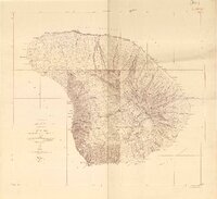 1923 Island of Lanai1923 Print · USGSLanai in the early twenties reveals a landscape of deep gulches and emerging inland settlement just as the pineapple era began. Trace coastal landmarks like Keomuku PO and Halepalaoa Landing or explore the harbor at Kaumalapau Harbor.2 unique versions available
 - 1925 Map of Island of Lanai
 1925 Island of Lanai1925 Print · USGSLanai is mapped here during the mid-twenties, showing the island's transition into a centralized plantation economy. Genealogists and historians can trace the early layout of Lanai City, the coastal Keomuku P O, and the ancient Kaa Fishpond.
 - 1954 Map of Maui
 1954 Maui1954 Print · USGSThe central Hawaiian Islands are shown during the mid-fifties, detailing the agricultural and coastal infrastructure of Maui, Lanai, and Molokai. Genealogists and researchers can trace plantation-era history at Haliimaile Camp, locate old harbors like Kaumalapau Harbor, or explore the early bounds of Haleakala National Park.
 - 1966 Map of Maui
 1966 Maui1966 Print · USGSThe central islands of Maui, Molokai, Lanai, and Kahoolawe are shown in detail during the mid-1960s as plantation life and early tourism coexisted. Genealogists and researchers can trace family locations in old plantation towns like Puunene, the harbor at Lahaina, and Hoolehua on Molokai.
 - 1974 Map of Maui
 1974 Maui1974 Print · USGSMid-century Hawaii is captured here through the detailed landscapes of Maui, Molokai, Lanai, and Kahoolawe as they appeared in the 1970s. Researchers can trace the layout of island hubs like Lahaina and Lanai City alongside remote landmarks like Wainapanapa Cave.2 unique versions available
 - 1984 Map of Lanai North
 1984 Lanai North1984 Print · USGSThe northern coast of Lanai in the mid-1980s reveals a landscape of isolated beaches and deep gulches. Researchers can trace the maritime history of Shipwreck Beach and locate the inland settlements of Lanai City and Koele near the island's heart.
 - 1991 Map of Makalau, 2000 Print
 1991 Makalau2000 Print · USGSThe northeast coast of the Lahaina District is captured here in the early nineties, showing a landscape defined by deep ravines and coastal fishponds. Researchers can trace the path of Keomuku Road past Shipwreck Beach and the historic Fishpond Keomuku.
 - 1992 Map of Haalelepaakai, 2000 Print
 1992 Haalelepaakai2000 Print · USGSLana'i City and the surrounding highlands are captured here in the early nineties as the island's landscape transitioned toward modern conservation. Researchers can trace historical sites from the Shrine (Buddhist Cem) to coastal Naha Fishpond and Halepalaoa Landing.
 - 2013 Map of Lanai North, 2013 Print
 2013 Lanai North2013 Print · USGSCovers Keomoku Village, including Keomuku, Maui County, and other nearby areas
 - 2017 Map of Lanai North, 2017 Print
 2017 Lanai North2017 Print · USGSCovers Keomoku Village, including Keomuku, Maui County, and other nearby areas
 - 2024 Map of Lanai North, 2024 Print
 2024 Lanai North2024 Print · USGSThe northern slopes of Lāna'i are showcased here during the mid-2020s, showing a landscape where high volcanic ridges meet the Pacific shore. Genealogists and hikers can trace connections between Lanai City and coastal landmarks like Keomuku and the Kaa Fishpond.
End of results
Showing maps 1-11 of 11
Top cities near Keomoku Village
Frequently asked questions
- What are the different types of historical maps available for Keomoku Village?
- What is the oldest map of Keomoku Village?
- Where can I purchase historical maps of Keomoku Village for my home or office?
- Where can I download high-res historical maps of Keomoku Village?
- Are there historical topographic maps available for Keomoku Village?
- Is there historical aerial imagery available for Keomoku Village?
- Where are historical maps of Keomoku Village sourced from?