Old Maps of Wailua, Hawaii for Metal Detecting
Plan your next treasure hunt with 9 historic maps of Wailua. Find old homesites, ghost towns, trails, and gathering spots that may be lost to time — perfect for identifying promising metal detecting locations.
- Locate forgotten sites: Uncover places like long-lost settlements, abandoned rail lines, or gathering spots.
- Plan better hunts: Use map overlays combined with LiDAR or satellite views to narrow in on historically rich areas.
- Made for detectorists: Thousands of hobbyists use these maps to discover relics, coins, and hidden history.
Use these historic maps to boost your research and find new opportunities beneath the surface of Wailua.
Wailua, HI maps
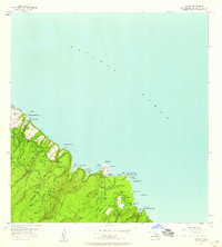
(9)- 1954 Map of Maui
 1954 Maui1954 Print · USGSThe central Hawaiian Islands are shown during the mid-fifties, detailing the agricultural and coastal infrastructure of Maui, Lanai, and Molokai. Genealogists and researchers can trace plantation-era history at Haliimaile Camp, locate old harbors like Kaumalapau Harbor, or explore the early bounds of Haleakala National Park.
 - 1957 Map of Keanae, 1959 Print
 1957 Keanae1959 Print · USGSCoastal Maui in the late fifties is captured here through its traditional homesteads and complex irrigation networks. Researchers can trace the layout of Keanae Homesteads, find the Keanae School, and locate remote waterworks like Spreckels Ditch.2 unique versions available
 - 1966 Map of Maui
 1966 Maui1966 Print · USGSThe central islands of Maui, Molokai, Lanai, and Kahoolawe are shown in detail during the mid-1960s as plantation life and early tourism coexisted. Genealogists and researchers can trace family locations in old plantation towns like Puunene, the harbor at Lahaina, and Hoolehua on Molokai.
 - 1974 Map of Maui
 1974 Maui1974 Print · USGSMid-century Hawaii is captured here through the detailed landscapes of Maui, Molokai, Lanai, and Kahoolawe as they appeared in the 1970s. Researchers can trace the layout of island hubs like Lahaina and Lanai City alongside remote landmarks like Wainapanapa Cave.2 unique versions available
 - 1983 Map of Keanae
 1983 Keanae1983 Print · USGSThe windward coast of East Maui comes to life in this early 1980s survey of the Keanae and Wailua peninsulas. Genealogists and historians can trace family land in the Keanae Homesteads and locate landmarks like the Keanae School and Old Keanae Landing.
 - 1992 Map of Keanae, 2003 Print
 1992 Keanae2003 Print · USGSThe coastal homesteads of Maui's Ke'anae region are captured here in the 1990s, where the winding Hana Highway meets the sea. Researchers can trace the layout of Ke'anae Homesteads, the Old Ke'anae Landing, and local landmarks like Ke'anae Sch.
 - 2013 Map of Keanae, 2013 Print
 2013 Keanae2013 Print · USGSCovers Wailua, including Keanae, Maui County, and other nearby areas
 - 2017 Map of Keanae, 2017 Print
 2017 Keanae2017 Print · USGSCovers Wailua, including Keanae, Maui County, and other nearby areas
 - 2024 Map of Keanae, 2024 Print
 2024 Keanae2024 Print · USGSCoastal Maui's windward shore is shown in this modern survey, highlighting the historic taro-growing regions and remote coastal villages. Trace the locations of Keanae Congregational Church Cem, the Ke'anae Arboretum, and the dramatic cascades of Ha'ipua'ena Falls.
End of results
Showing maps 1-9 of 9
Top cities near Wailua
Frequently asked questions
- What are the different types of historical maps available for Wailua?
- What is the oldest map of Wailua?
- Where can I purchase historical maps of Wailua for my home or office?
- Where can I download high-res historical maps of Wailua?
- Are there historical topographic maps available for Wailua?
- Is there historical aerial imagery available for Wailua?
- Where are historical maps of Wailua sourced from?