1950s Maps of Avimor, Idaho
Explore 4 historic maps of Avimor from the 1950s. These maps offer a rare glimpse into what life looked like during the 1950s — showing old roads, neighborhoods, homes, and landmarks that have changed or disappeared over time.
Whether you're researching your family's past, planning a metal detecting trip, or studying how Avimor's landscape evolved across the 1950s, these high-resolution maps are a powerful tool for exploring the history of this region.
- Focus on a specific era: All maps on this page are from the 1950s, giving you a focused view of this time period.
- See what’s changed: Compare century-old streets, trails, and buildings to today's modern landscape using overlays and satellite layers.
- Research with precision: Use these maps for genealogy, historical research, land use analysis, or educational projects.
- View, download, or print: Maps are fully viewable online in high resolution, and can be downloaded or printed for your own records.
Start exploring Avimor's history through authentic maps from the 1950s. This is your window into the past.
Avimor, ID maps
(4)- 1953 Map of Montour, 1956 Print
 1953 Montour1956 Print · USGSThe Payette River valley in the early fifties shows a landscape of reclamation and resource extraction. Researchers can trace the rail corridor of the Union Pacific or locate early mining sites like the Gem State Mine and the Sweet Cemetery.3 unique versions available
 - 1955 Map of Boise, 1977 Print
 1955 Boise1977 Print · USGSThe Treasure Valley and Owyhee uplands are shown in detail during the mid-fifties, capturing the region's transition into a major agricultural and urban hub. Researchers can trace the Union Pacific line through Nampa, explore the volcanic Jordan Craters, or locate the historic mining district of Silver City.
 - 1957 Map of Cartwright Canyon, 1959 Print
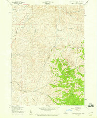 1957 Cartwright Canyon1959 Print · USGSThe foothills north of Boise during the late 1950s remained a terrain of remote ranching and timber access. Researchers can trace the original route of Horseshoe Bend Road and locate family landmarks like Dobson Ranch and Stack Rock.4 unique versions available
 - 1958 Map of Boise
 1958 Boise1958 Print · USGSThe Treasure Valley and Snake River Plain come alive in the mid-fifties as the rail-and-river economy transitions into a modern agricultural hub. Trace the Union Pacific lines through Nampa or locate remote landmarks like Initial Point and the Rockville settlement.2 unique versions available
End of results
Showing maps 1-4 of 4
Top cities near Avimor
- Boise historical maps
- Meridian historical maps
- Nampa historical maps
- Eagle historical maps
- Kuna historical maps
- Star historical maps
See more
Top neighborhoods of Avimor
Frequently asked questions
- What are the different types of historical maps available for Avimor?
- What is the oldest map of Avimor?
- Where can I purchase historical maps of Avimor for my home or office?
- Where can I download high-res historical maps of Avimor?
- Are there historical topographic maps available for Avimor?
- Is there historical aerial imagery available for Avimor?
- Where are historical maps of Avimor sourced from?