1940s Maps of Bannock County, Idaho
Explore 5 historic maps of Bannock County from the 1940s. These maps offer a rare glimpse into what life looked like during the 1940s — showing old roads, neighborhoods, homes, and landmarks that have changed or disappeared over time.
Whether you're researching your family's past, planning a metal detecting trip, or studying how Bannock County's landscape evolved across the 1940s, these high-resolution maps are a powerful tool for exploring the history of this region.
- Focus on a specific era: All maps on this page are from the 1940s, giving you a focused view of this time period.
- See what’s changed: Compare century-old streets, trails, and buildings to today's modern landscape using overlays and satellite layers.
- Research with precision: Use these maps for genealogy, historical research, land use analysis, or educational projects.
- View, download, or print: Maps are fully viewable online in high resolution, and can be downloaded or printed for your own records.
Start exploring Bannock County's history through authentic maps from the 1940s. This is your window into the past.
Bannock County, ID maps
(5)- 1940 Map of Blackfoot, 1958 Print
 1940 Blackfoot1958 Print · USGSBingham County at the dawn of the 1940s reveals a landscape defined by the Snake River and a vast irrigation network. Genealogists and historians can trace the Fort Hall Indian Reservation boundaries, find School No 12, and locate the Indian Agency and Ross Fork Indian Sch.
 - 1943 Map of Blackfoot
 1943 Blackfoot1943 Print · USGSSoutheastern Idaho's river valleys and irrigation networks are on full display in the early 1940s, centered on the confluence of the Snake River and Blackfoot River. Genealogists and historians can trace family-named waterworks like Wearyrick Ditch and explore the historic layout of the Fort Hall Indian Reservation and Blackfoot.2 unique versions available
 - 1944 Map of Pocatello
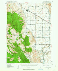
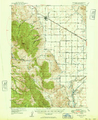
 1944 Pocatello1944 Print · USGSBannock County and the Fort Hall Indian Reservation are captured here in the years leading up to the second World War. Researchers can trace the early streets of Pocatello and Alameda, or locate rural landmarks like the Portneuf Sch and the Fort Hall Mine.
 - 1948 Map of Bancroft, 1963 Print
 1948 Bancroft1963 Print · USGSBancroft and the Gentile Valley are captured here during the post-war era of hydroelectric and agricultural expansion. Local historians can trace the irrigation canals and power plants along the Bear River, alongside vanished landmarks like the Telluride Sch and Leadville Mine.2 unique versions available
 - 1949 Map of Bancroft
 1949 Bancroft1949 Print · USGSBancroft and the Gentile Valley are captured here in the late 1940s, showing a landscape defined by the Union Pacific rail line and early hydroelectric power. Researchers can locate the Leadville Mine, the Telluride School, and numerous family-named landmarks like Kackley Spr and Barfuss Road.
End of results
Showing maps 1-5 of 5
Top cities of Bannock County
- Pocatello historical maps
- McCammon historical maps
- Inkom historical maps
- Downey historical maps
- Lava Hot Springs historical maps
- Arimo historical maps
Frequently asked questions
- What are the different types of historical maps available for Bannock County?
- What is the oldest map of Bannock County?
- Where can I purchase historical maps of Bannock County for my home or office?
- Where can I download high-res historical maps of Bannock County?
- Are there historical topographic maps available for Bannock County?
- Is there historical aerial imagery available for Bannock County?
- Where are historical maps of Bannock County sourced from?