1970s Maps of Bannock County, Idaho
Explore 12 historic maps of Bannock County from the 1970s. These maps offer a rare glimpse into what life looked like during the 1970s — showing old roads, neighborhoods, homes, and landmarks that have changed or disappeared over time.
Whether you're researching your family's past, planning a metal detecting trip, or studying how Bannock County's landscape evolved across the 1970s, these high-resolution maps are a powerful tool for exploring the history of this region.
- Focus on a specific era: All maps on this page are from the 1970s, giving you a focused view of this time period.
- See what’s changed: Compare century-old streets, trails, and buildings to today's modern landscape using overlays and satellite layers.
- Research with precision: Use these maps for genealogy, historical research, land use analysis, or educational projects.
- View, download, or print: Maps are fully viewable online in high resolution, and can be downloaded or printed for your own records.
Start exploring Bannock County's history through authentic maps from the 1970s. This is your window into the past.
Bannock County, ID maps
(12)- 1971 Map of Fort Hall, 1974 Print
 1971 Fort Hall1974 Print · USGSThe Fort Hall Indian Reservation in the early seventies shows a complex landscape of irrigation and rail. Genealogists and historians can trace local landmarks like Fort Hall Indian Agency, Good Shepherd Cem, and the prominent Ferry Butte.
 - 1971 Map of Inkom, 1974 Print
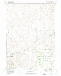
 1971 Inkom1974 Print · USGSInkom and the Portneuf River valley are captured in the early seventies as a hub for rail transport and mountain recreation. Researchers can trace the Union Pacific line, locate the Silver Sage Girl Scout Camp, and find the historic Fort Hall Mine near the forest boundary.2 unique versions available
 - 1971 Map of Buckskin Basin, 1974 Print
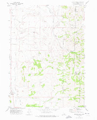
 1971 Buckskin Basin1974 Print · USGSThe Fort Hall Indian Reservation in the early seventies shows a landscape shaped by irrigation and rail. Researchers can trace the Fort Hall Main Canal and locate the Ross Fork Indian School and Ross Fork Cem.
 - 1971 Map of Pocatello North, 1974 Print
 1971 Pocatello North1974 Print · USGSNorth of Pocatello during the early seventies, the landscape shows a transition from the Fort Hall Indian Reservation Boundary to growing suburban tracts. Local historians can trace development through labels for the Drive-in Theater, Chubbuck School, and the Union Pacific line.2 unique versions available
 - 1971 Map of Moonlight Mtn, 1974 Print
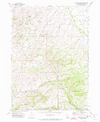 1971 Moonlight Mtn1974 Print · USGSBannock County was a landscape of high-altitude ridges and reservation boundaries during the early 1970s. Trace old mining activity and water rights through the Moonlight Mine and vital water sources like Little Horse Spring and Pine Spring.2 unique versions available
 - 1971 Map of Schiller, 1974 Print
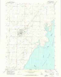
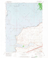 1971 Schiller1974 Print · USGSPower County, Idaho, is captured here in the early 1970s as the regional economy revolved around the Snake River shoreline and the Michaud Flats. Genealogists and historians can trace the Union Pacific rail line, the rural settlement of Schiller, and the Indian Cem within the Fort Hall Indian Reservation.
 - 1971 Map of Michaud Creek, 1974 Print
 1971 Michaud Creek1974 Print · USGSPower and Bannock counties meet in this early 1970s landscape of high-desert canyons and reservation lands. Researchers can trace the boundary of the Fort Hall Indian Reservation and locate specific landmarks like Eagletail Rock, the local Cem, and Outlaw Spring.2 unique versions available
 - 1971 Map of Michaud, 1974 Print
 1971 Michaud1974 Print · USGSPower County and the Fort Hall Indian Reservation meet here in the early seventies as the Portneuf River feeds the reservoir. Genealogists and historians can trace family-named roads and sites like Reider Cemetery, Indian Cem, and the settlement of Michaud.4 unique versions available
 - 1971 Map of Aberdeen, 1974 Print
 1971 Aberdeen1974 Print · USGSBingham County agriculture and the Snake River irrigation network are in full view in the early seventies. Genealogists and historians can locate the Cem, the High Sch, and the local Aberdeen Airport amidst the Union Pacific rail lines.
 - 1971 Map of Pocatello South, 1974 Print
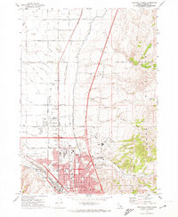
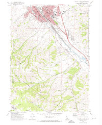 1971 Pocatello South1974 Print · USGSPocatello and the Portneuf River valley are captured in the early 1970s, showing the city's growth alongside Idaho State University. Trace local landmarks like Mountain View Cemetery, the Union Pacific rail lines, and Kinport Peak.3 unique versions available
 - 1974 Map of Pocatello North, 1975 Print
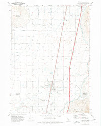
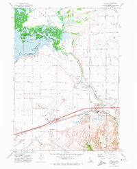
 1974 Pocatello North1975 Print · USGSSoutheastern Idaho's urban-rural boundary is captured in the mid-1970s as the northern expansion of Pocatello meets the surrounding farmland. Genealogists and local historians can trace the development of Chubbuck and the rural outpost of Tyhee along the Portneuf River valley.
 - 1978 Map of Blackfoot, 1997 Print
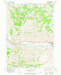
 1978 Blackfoot1997 Print · USGSThe Snake River Valley in the late 1970s shows a landscape of volcanic lava flows meeting intensive irrigation. Genealogists and local historians can trace the irrigation canals and rail towns from Atomic City to the Fort Hall Indian Reservation and Gay Mine.
End of results
Showing maps 1-12 of 12
Top cities of Bannock County
- Pocatello historical maps
- McCammon historical maps
- Inkom historical maps
- Downey historical maps
- Lava Hot Springs historical maps
- Arimo historical maps
Frequently asked questions
- What are the different types of historical maps available for Bannock County?
- What is the oldest map of Bannock County?
- Where can I purchase historical maps of Bannock County for my home or office?
- Where can I download high-res historical maps of Bannock County?
- Are there historical topographic maps available for Bannock County?
- Is there historical aerial imagery available for Bannock County?
- Where are historical maps of Bannock County sourced from?