1980s Maps of Plummer, Idaho
Explore 3 historic maps of Plummer from the 1980s. These maps offer a rare glimpse into what life looked like during the 1980s — showing old roads, neighborhoods, homes, and landmarks that have changed or disappeared over time.
Whether you're researching your family's past, planning a metal detecting trip, or studying how Plummer's landscape evolved across the 1980s, these high-resolution maps are a powerful tool for exploring the history of this region.
- Focus on a specific era: All maps on this page are from the 1980s, giving you a focused view of this time period.
- See what’s changed: Compare century-old streets, trails, and buildings to today's modern landscape using overlays and satellite layers.
- Research with precision: Use these maps for genealogy, historical research, land use analysis, or educational projects.
- View, download, or print: Maps are fully viewable online in high resolution, and can be downloaded or printed for your own records.
Start exploring Plummer's history through authentic maps from the 1980s. This is your window into the past.
Plummer, ID maps
(3)- 1981 Map of St Maries
 1981 St Maries1981 Print · USGSThe timber and rail hub of St. Maries is captured here in the early 1980s as the river-and-rail economy defined the Panhandle. Researchers can trace historic transport corridors including the Union Pacific tracks and remote landings along the St Joe River and Chatcolet Lake.2 unique versions available
 - 1981 Map of Plummer, 1982 Print
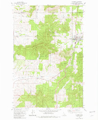 1981 Plummer1982 Print · USGSPlummer and the surrounding reservation lands are captured in the early eighties as the rail era transitioned to local roads. Researchers can trace the Old Railroad Grade through the Sorrento Tunnel or locate landmarks like the Drive-in Theater.
 - 1981 Map of Chatcolet, 1982 Print
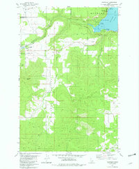 1981 Chatcolet1982 Print · USGSBenewah County’s lakeside and timberlands are captured here in the early 1980s, centered on the historic rail-and-water corridor of Chatcolet Lake. Researchers can trace the routes of the Union Pacific railroad and locate local landmarks like Hawleys Landing and Plummer Junction.
End of results
Showing maps 1-3 of 3
Top cities near Plummer
- Tekoa historical maps
- Harrison historical maps
- Worley historical maps
- De Smet historical maps
- Tensed historical maps
Frequently asked questions
- What are the different types of historical maps available for Plummer?
- What is the oldest map of Plummer?
- Where can I purchase historical maps of Plummer for my home or office?
- Where can I download high-res historical maps of Plummer?
- Are there historical topographic maps available for Plummer?
- Is there historical aerial imagery available for Plummer?
- Where are historical maps of Plummer sourced from?