1980s Maps of Talache, Idaho
Explore 2 historic maps of Talache from the 1980s. These maps offer a rare glimpse into what life looked like during the 1980s — showing old roads, neighborhoods, homes, and landmarks that have changed or disappeared over time.
Whether you're researching your family's past, planning a metal detecting trip, or studying how Talache's landscape evolved across the 1980s, these high-resolution maps are a powerful tool for exploring the history of this region.
- Focus on a specific era: All maps on this page are from the 1980s, giving you a focused view of this time period.
- See what’s changed: Compare century-old streets, trails, and buildings to today's modern landscape using overlays and satellite layers.
- Research with precision: Use these maps for genealogy, historical research, land use analysis, or educational projects.
- View, download, or print: Maps are fully viewable online in high resolution, and can be downloaded or printed for your own records.
Start exploring Talache's history through authentic maps from the 1980s. This is your window into the past.
Talache, ID maps
(2)- 1984 Map of Sandpoint
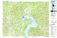 1984 Sandpoint1984 Print · USGSThe Idaho Panhandle in the early 1980s shows a landscape of deep lakes and working forests centered on the rail hub of Sandpoint. Researchers can trace the legacy of regional industry through the Spokane International rail lines and mining sites like the Gold Coin Mine and Sulphide Mine.2 unique versions available
 - 1989 Map of Talache
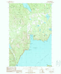 1989 Talache1989 Print · USGSThe western shoreline of Lake Pend Oreille reveals its mining and timber roots during the late twentieth century. Researchers can trace historical sites like the Garfield (Midas) Gold Coin Mine, the Newman Sch, and local cemeteries near Talache.
End of results
Showing maps 1-2 of 2
Top cities near Talache
- Sandpoint historical maps
- Ponderay historical maps
- Athol historical maps
- Dover historical maps
- Kootenai historical maps
- East Hope historical maps
See more
Frequently asked questions
- What are the different types of historical maps available for Talache?
- What is the oldest map of Talache?
- Where can I purchase historical maps of Talache for my home or office?
- Where can I download high-res historical maps of Talache?
- Are there historical topographic maps available for Talache?
- Is there historical aerial imagery available for Talache?
- Where are historical maps of Talache sourced from?