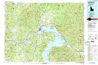
1984 Map of Sandpoint
USGS Topo · Published 1984About this map
The waters of Lake Pend Oreille and the Pend Oreille River dominate this Northern Idaho landscape, anchored by the regional hub of Sandpoint. In the mid-1980s, the area reflects a complex transition between a resource-based economy and a growing recreation destination. The Albeni Falls Dam regulates the river west of Laclede, while the extensive reaches of the Kaniksu National Forest and the Priest River Experimental Forest surround the settled valleys. Traces of older mining operations are evident at the Sulphide Mine and the Hope and Faith Shaft, while the transportation corridor remains defined by the Spokane International and Burlington Northern railroads. Small landings and settlements like Talache Landing, Glengary, and Coolin sit at the forest edges, illustrating the rugged geography that hemmed in early development.
Find a feature on this map
190 named features on this map. Tap any name to fly to it.
Don’t see what you’re looking for? This feature index may not catch every label — zoom into the map to look around manually.
Map Details
Editions of this 1984 Sandpoint Map
2 editions found
Other maps of this area

1901 · Sandpoint
USGS Topo · 1:125,000

1901 · Spokane
USGS Topo · 1:125,000

1903 · Rathdrum
USGS Topo · 1:125,000

1909 · Cataldo
USGS Topo · 1:125,000

1911 · Cataldo
USGS Topo · 1:125,000

1911 · Priest Lake
USGS Topo · 1:250,000

1911 · Sandpoint
USGS Topo · 1:125,000

1913 · Priest Lake
USGS Topo · 1:250,000

1920 · Libby
USGS Topo · 1:125,000

1930 · Libby
USGS Topo · 1:125,000