
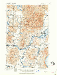
1911 Map of Sandpoint
USGS Topo · Published 1959About this map
Sandpoint and the surrounding Idaho panhandle are depicted here following a 1911 revision, showcasing a landscape defined by its timbered slopes and river-based transport. The rugged topography of the Selkirk Mountains dominates the central portion of the sheet, largely contained within the Kaniksu National Forest. Transportation at this time relied heavily on both the river system and the burgeoning rail network, with multiple ferries such as Baldwin Ferry and Hamill Ferry providing vital crossings on the Priest River.
Find a feature on this map
81 named features on this map. Tap any name to fly to it.
Don’t see what you’re looking for? This feature index may not catch every label — zoom into the map to look around manually.
Map Details
Editions of this 1911 Sandpoint Map
2 editions found
Other maps of this area

1901 · Sandpoint
USGS Topo · 1:125,000

1901 · Spokane
USGS Topo · 1:125,000

1903 · Rathdrum
USGS Topo · 1:125,000

1909 · Cataldo
USGS Topo · 1:125,000

1911 · Cataldo
USGS Topo · 1:125,000

1911 · Priest Lake
USGS Topo · 1:250,000

1913 · Priest Lake
USGS Topo · 1:250,000

1934 · Metaline
USGS Topo · 1:125,000

1936 · Newport
USGS Topo · 1:96,000

1942 · Metaline
USGS Topo · 1:125,000