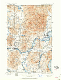
1911 Map of Sandpoint
USGS Topo · Published 1960About this map
Sandpoint serves as the focal point of this Northern Idaho landscape, situated where the Great Northern and Northern Pacific railroads meet the northern shores of Pend Oreille Lake. The map reveals a region defined by its water-based transportation and timber resources, with several essential river crossings such as Baldwin Ferry and Markham Ferry providing transit before the dominance of modern bridges. The Pend Oreille River flows westward past Riverside and Laclede, while the southern reaches of Priest Lake and the settlement of Coolin are visible to the north.
Find a feature on this map
68 named features on this map. Tap any name to fly to it.
Don’t see what you’re looking for? This feature index may not catch every label — zoom into the map to look around manually.
Map Details
Editions of this 1911 Sandpoint Map
2 editions found
Other maps of this area

1901 · Sandpoint
USGS Topo · 1:125,000

1901 · Spokane
USGS Topo · 1:125,000

1903 · Rathdrum
USGS Topo · 1:125,000

1909 · Cataldo
USGS Topo · 1:125,000

1911 · Cataldo
USGS Topo · 1:125,000

1911 · Priest Lake
USGS Topo · 1:250,000

1911 · Sandpoint
USGS Topo · 1:125,000

1913 · Priest Lake
USGS Topo · 1:250,000

1934 · Metaline
USGS Topo · 1:125,000

1936 · Newport
USGS Topo · 1:96,000