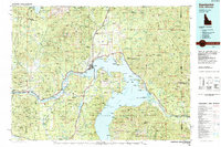
1984 Map of Sandpoint
USGS Topo · Published 1984About this map
Pend Oreille Lake dominates the center of this 1984 survey, where the Burlington Northern railroad corridor meets the commercial hub of Sandpoint. The map documents a rugged landscape defined by the intersection of the Selkirk Mountains, Purcell Mountains, and Cabinet Mountains. Small settlements such as Cocolalla, Sagle, and Laclede appear alongside historical extraction sites like the Sulphide Mine and Hope Mine, illustrating the region's transition from early mining and timber interests to modern forestry and recreation.
Find a feature on this map
210 named features on this map. Tap any name to fly to it.
Don’t see what you’re looking for? This feature index may not catch every label — zoom into the map to look around manually.
Map Details
Editions of this 1984 Sandpoint Map
2 editions found
Other maps of this area

1901 · Sandpoint
USGS Topo · 1:125,000

1901 · Spokane
USGS Topo · 1:125,000

1903 · Rathdrum
USGS Topo · 1:125,000

1909 · Cataldo
USGS Topo · 1:125,000

1911 · Cataldo
USGS Topo · 1:125,000

1911 · Priest Lake
USGS Topo · 1:250,000

1911 · Sandpoint
USGS Topo · 1:125,000

1913 · Priest Lake
USGS Topo · 1:250,000

1920 · Libby
USGS Topo · 1:125,000

1930 · Libby
USGS Topo · 1:125,000