1960s Maps of Canyon County, Idaho
Explore 6 historic maps of Canyon County from the 1960s. These maps offer a rare glimpse into what life looked like during the 1960s — showing old roads, neighborhoods, homes, and landmarks that have changed or disappeared over time.
Whether you're researching your family's past, planning a metal detecting trip, or studying how Canyon County's landscape evolved across the 1960s, these high-resolution maps are a powerful tool for exploring the history of this region.
- Focus on a specific era: All maps on this page are from the 1960s, giving you a focused view of this time period.
- See what’s changed: Compare century-old streets, trails, and buildings to today's modern landscape using overlays and satellite layers.
- Research with precision: Use these maps for genealogy, historical research, land use analysis, or educational projects.
- View, download, or print: Maps are fully viewable online in high resolution, and can be downloaded or printed for your own records.
Start exploring Canyon County's history through authentic maps from the 1960s. This is your window into the past.
Canyon County, ID maps
(6)- 1962 Map of Boise
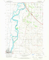
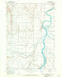
 1962 Boise1962 Print · USGSThe Treasure Valley at the start of the sixties reveals a landscape of expanding towns and complex irrigation networks along the Snake River. Genealogists and historians can trace the foundations of modern Idaho through markers like Initial Point, the mining history of Silver City, and the early infrastructure of Lucky Peak Dam.
 - 1965 Map of Nyssa, 1967 Print
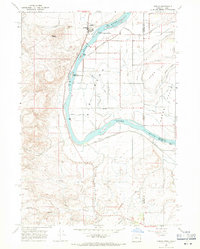
 1965 Nyssa1967 Print · USGSThe borderlands of Oregon and Idaho come alive in the mid-1960s as the Snake River winds past Nyssa and its surrounding agricultural islands. Genealogists and historians can trace local landmarks like the De Lamar Grange Hall, the Union Pacific rail lines, and the extensive irrigation networks of Farmers Ditch.
 - 1965 Map of Parma, 1967 Print
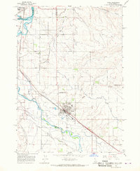 1965 Parma1967 Print · USGSWestern Idaho's river junctions and rail corridors come into focus in the mid-sixties as the irrigation network supports the growing valley. Researchers can trace family roots at Parma Cem, locate the Apple Valley Sch, or explore the grounds of the University of Idaho Agriculture Experiment Sta.2 unique versions available
 - 1965 Map of Parma SE, 1967 Print
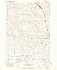 1965 Parma SE1967 Print · USGSThe agricultural border of Payette and Canyon counties comes into focus in the mid-sixties, showcasing a sophisticated network of desert irrigation. Local historians can trace the specific routes of the Black Canyon Canal, the crossing at Rookstool Corner, and the path of the Sebree Canal.2 unique versions available
 - 1967 Map of Adrian, 1971 Print
 1967 Adrian1971 Print · USGSThe Oregon-Idaho border along the Snake River is captured here in the late sixties, showing a landscape defined by irrigation and the rail line. Researchers can trace the Union Pacific tracks through Adrian and Napton, or locate rural landmarks like Big Bend School and Brown Butte.2 unique versions available
 - 1967 Map of Owyhee, 1971 Print
 1967 Owyhee1971 Print · USGSThe Oregon-Idaho borderlands in the late sixties reveal a landscape shaped by the meeting of three rivers and a vast irrigation network. Researchers can trace the heritage of Nyssa and Overstreet, locating the Owyhee Cemetery and the industrial infrastructure of the Union Pacific railroad.2 unique versions available
End of results
Showing maps 1-6 of 6
Top cities of Canyon County
- Nampa historical maps
- Caldwell historical maps
- Middleton historical maps
- Parma historical maps
- Wilder historical maps
- Greenleaf historical maps
See more
Frequently asked questions
- What are the different types of historical maps available for Canyon County?
- What is the oldest map of Canyon County?
- Where can I purchase historical maps of Canyon County for my home or office?
- Where can I download high-res historical maps of Canyon County?
- Are there historical topographic maps available for Canyon County?
- Is there historical aerial imagery available for Canyon County?
- Where are historical maps of Canyon County sourced from?