1950s Maps of Challis, Idaho
Explore 2 historic maps of Challis from the 1950s. These maps offer a rare glimpse into what life looked like during the 1950s — showing old roads, neighborhoods, homes, and landmarks that have changed or disappeared over time.
Whether you're researching your family's past, planning a metal detecting trip, or studying how Challis's landscape evolved across the 1950s, these high-resolution maps are a powerful tool for exploring the history of this region.
- Focus on a specific era: All maps on this page are from the 1950s, giving you a focused view of this time period.
- See what’s changed: Compare century-old streets, trails, and buildings to today's modern landscape using overlays and satellite layers.
- Research with precision: Use these maps for genealogy, historical research, land use analysis, or educational projects.
- View, download, or print: Maps are fully viewable online in high resolution, and can be downloaded or printed for your own records.
Start exploring Challis's history through authentic maps from the 1950s. This is your window into the past.
Challis, ID maps
(2)- 1956 Map of Challis, 1960 Print
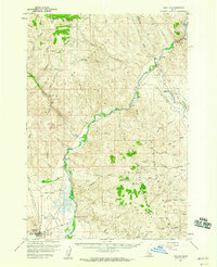 1956 Challis1960 Print · USGSThe Salmon River valley comes into focus during the mid-1950s, showing the settlement of Challis and its vital mountain infrastructure. Researchers can trace local landmarks like Beardsley Hot Springs, the Challis Airfield, and family-named routes such as Burstadt Lane.2 unique versions available
 - 1957 Map of Challis, 1964 Print
 1957 Challis1964 Print · USGSCentral Idaho in the late fifties and early sixties remains a territory of remote mining camps and high-mountain ranger stations. Trace historic mining operations like the Lucky Boy Mine or locate isolated homesteads including Robinson Bar Ranch and Allison Ranch.3 unique versions available
End of results
Showing maps 1-2 of 2
Top cities near Challis
Top neighborhoods of Challis
Frequently asked questions
- What are the different types of historical maps available for Challis?
- What is the oldest map of Challis?
- Where can I purchase historical maps of Challis for my home or office?
- Where can I download high-res historical maps of Challis?
- Are there historical topographic maps available for Challis?
- Is there historical aerial imagery available for Challis?
- Where are historical maps of Challis sourced from?