1960s Maps of Dayton, Idaho
Explore 5 historic maps of Dayton from the 1960s. These maps offer a rare glimpse into what life looked like during the 1960s — showing old roads, neighborhoods, homes, and landmarks that have changed or disappeared over time.
Whether you're researching your family's past, planning a metal detecting trip, or studying how Dayton's landscape evolved across the 1960s, these high-resolution maps are a powerful tool for exploring the history of this region.
- Focus on a specific era: All maps on this page are from the 1960s, giving you a focused view of this time period.
- See what’s changed: Compare century-old streets, trails, and buildings to today's modern landscape using overlays and satellite layers.
- Research with precision: Use these maps for genealogy, historical research, land use analysis, or educational projects.
- View, download, or print: Maps are fully viewable online in high resolution, and can be downloaded or printed for your own records.
Start exploring Dayton's history through authentic maps from the 1960s. This is your window into the past.
Dayton, ID maps
(5)- 1962 Map of Preston
 1962 Preston1962 Print · USGSSoutheast Idaho and the Wyoming borderlands are captured here in the early sixties, a time of thriving agricultural valleys and mountain ranching. Researchers can trace the Union Pacific rail lines and find legacy settlements like Montpelier, Afton, and Preston.
 - 1968 Map of Clifton, 1971 Print
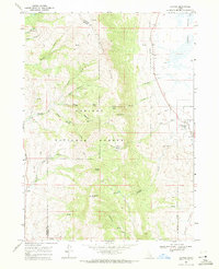 1968 Clifton1971 Print · USGSIn the late sixties, the ranching country near Clifton remained a world of mountain basins and complex water rights. Genealogists and local historians can trace the paths of the Pack Trail through North Fork Mine Hollow or locate high-elevation landmarks like Weston Peak and Davis Basin.3 unique versions available
 - 1968 Map of Weston Canyon, 1971 Print
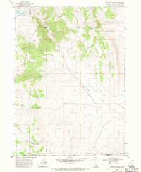 1968 Weston Canyon1971 Print · USGSFranklin and Oneida counties meet in this late-1960s survey of the Idaho-Utah borderlands, where mountain canyons give way to high-desert flats. Genealogists and historians can locate remote landmarks like Standing Rock, Weston Creek Reservoir, and the Washboards.2 unique versions available
 - 1969 Map of Weston, 1973 Print
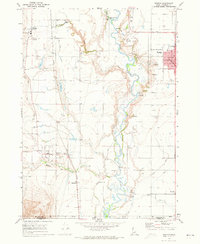 1969 Weston1973 Print · USGSFranklin County's irrigation and rail network are on full display in the late 1960s, centered on the growing hubs of Preston and Weston. Researchers can trace the Union Pacific line past local landmarks like the Little Santa Anita Racetrack and the Historical Monument near Dayton.2 unique versions available
 - 1969 Map of Banida, 1973 Print
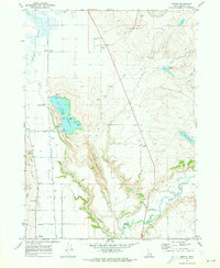 1969 Banida1973 Print · USGSFranklin County's irrigation and rail landscape is captured here in the late sixties as agricultural development shaped the valley. Genealogists and local historians can trace family roots through small settlements like Banida and Dayton or locate the Pioneer Women Historical Monument and Wayland Hot Springs.
End of results
Showing maps 1-5 of 5
Top cities near Dayton
- Preston historical maps
- Richmond historical maps
- Lewiston historical maps
- Franklin historical maps
- Clarkston historical maps
- Weston historical maps
See more
Frequently asked questions
- What are the different types of historical maps available for Dayton?
- What is the oldest map of Dayton?
- Where can I purchase historical maps of Dayton for my home or office?
- Where can I download high-res historical maps of Dayton?
- Are there historical topographic maps available for Dayton?
- Is there historical aerial imagery available for Dayton?
- Where are historical maps of Dayton sourced from?