1950s Maps of Gem County, Idaho
Explore 8 historic maps of Gem County from the 1950s. These maps offer a rare glimpse into what life looked like during the 1950s — showing old roads, neighborhoods, homes, and landmarks that have changed or disappeared over time.
Whether you're researching your family's past, planning a metal detecting trip, or studying how Gem County's landscape evolved across the 1950s, these high-resolution maps are a powerful tool for exploring the history of this region.
- Focus on a specific era: All maps on this page are from the 1950s, giving you a focused view of this time period.
- See what’s changed: Compare century-old streets, trails, and buildings to today's modern landscape using overlays and satellite layers.
- Research with precision: Use these maps for genealogy, historical research, land use analysis, or educational projects.
- View, download, or print: Maps are fully viewable online in high resolution, and can be downloaded or printed for your own records.
Start exploring Gem County's history through authentic maps from the 1950s. This is your window into the past.
Gem County, ID maps
(8)- 1953 Map of Smiths Ferry, 1955 Print
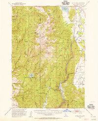 1953 Smiths Ferry1955 Print · USGSThe Payette River valley in the early fifties was a landscape of remote rail stops and mountain lookouts. Genealogists can trace rural school locations like Lower Alpha School (Aban'd) or follow the UNION PACIFIC line through Smiths Ferry.3 unique versions available
 - 1953 Map of Banks, 1955 Print
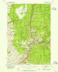 1953 Banks1955 Print · USGSThe confluence of the Payette River forks defines this mid-century survey of Boise and Valley counties. Genealogists can trace the rural mountain life of the early fifties through the High Valley Sch (Aband), Pinehurst Church, and the settlement of Banks.3 unique versions available
 - 1953 Map of Montour, 1956 Print
 1953 Montour1956 Print · USGSThe Payette River valley in the early fifties shows a landscape of reclamation and resource extraction. Researchers can trace the rail corridor of the Union Pacific or locate early mining sites like the Gem State Mine and the Sweet Cemetery.3 unique versions available
 - 1954 Map of Cascade, 1956 Print
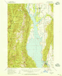 1954 Cascade1956 Print · USGSThe High Valley of the Payette River is captured here in the mid-fifties as the new reservoir redefines the landscape. Genealogists and historians can locate early settlements like Roseberry and Donnelly, the Hopps Cemetery, and high-country landmarks like Mica Mine.2 unique versions available
 - 1955 Map of Baker, 1964 Print
 1955 Baker1964 Print · USGSThe Oregon-Idaho borderlands are captured here in the mid-fifties as the Snake River underwent massive changes from dam construction. Trace the Oregon Trail Memorial Monument near Baker, find early mines like Virtue Mine, and follow the Union Pacific Railroad through Huntington.4 unique versions available
 - 1955 Map of Boise, 1977 Print
 1955 Boise1977 Print · USGSThe Treasure Valley and Owyhee uplands are shown in detail during the mid-fifties, capturing the region's transition into a major agricultural and urban hub. Researchers can trace the Union Pacific line through Nampa, explore the volcanic Jordan Craters, or locate the historic mining district of Silver City.
 - 1958 Map of Boise
 1958 Boise1958 Print · USGSThe Treasure Valley and Snake River Plain come alive in the mid-fifties as the rail-and-river economy transitions into a modern agricultural hub. Trace the Union Pacific lines through Nampa or locate remote landmarks like Initial Point and the Rockville settlement.2 unique versions available
 - 1959 Map of Baker
 1959 Baker1959 Print · USGSThe Oregon and Idaho borderlands come alive in the late fifties, showing the rugged corridor along the Snake River and the high peaks of the Wallowa Mountains. Researchers can trace the legacy of the Union Pacific railroad or locate historic mining sites like the Flagstaff Mine and Virtue Mine.2 unique versions available
End of results
Showing maps 1-8 of 8
Top cities of Gem County
Frequently asked questions
- What are the different types of historical maps available for Gem County?
- What is the oldest map of Gem County?
- Where can I purchase historical maps of Gem County for my home or office?
- Where can I download high-res historical maps of Gem County?
- Are there historical topographic maps available for Gem County?
- Is there historical aerial imagery available for Gem County?
- Where are historical maps of Gem County sourced from?