1970s Maps of Emmett, Idaho
Explore 2 historic maps of Emmett from the 1970s. These maps offer a rare glimpse into what life looked like during the 1970s — showing old roads, neighborhoods, homes, and landmarks that have changed or disappeared over time.
Whether you're researching your family's past, planning a metal detecting trip, or studying how Emmett's landscape evolved across the 1970s, these high-resolution maps are a powerful tool for exploring the history of this region.
- Focus on a specific era: All maps on this page are from the 1970s, giving you a focused view of this time period.
- See what’s changed: Compare century-old streets, trails, and buildings to today's modern landscape using overlays and satellite layers.
- Research with precision: Use these maps for genealogy, historical research, land use analysis, or educational projects.
- View, download, or print: Maps are fully viewable online in high resolution, and can be downloaded or printed for your own records.
Start exploring Emmett's history through authentic maps from the 1970s. This is your window into the past.
Emmett, ID maps
(2)- 1970 Map of Southwest Emmett, 1973 Print
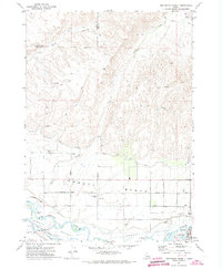
 1970 Southwest Emmett1973 Print · USGSThe Emmett Valley was a complex landscape of irrigation and industry in the early seventies, defined by the Payette River and its many canals. Researchers can trace rural school districts like Vanderdasson School or locate the historic Del Monte and Cold House sites along the Union Pacific tracks.
 - 1971 Map of Northwest Emmett, 1973 Print
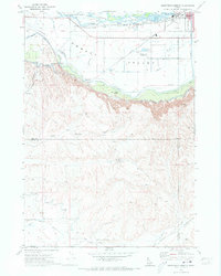
 1971 Northwest Emmett1973 Print · USGSThe Payette River valley in the early seventies shows a landscape shaped by irrigation and rail. Genealogists and historians can trace rural roots at Brick Sch, Central Mesa Sch, and the Emmett Cem along the Union Pacific line.
End of results
Showing maps 1-2 of 2
Top cities near Emmett
- Boise historical maps
- Meridian historical maps
- Nampa historical maps
- Caldwell historical maps
- Eagle historical maps
- Star historical maps
See more
Frequently asked questions
- What are the different types of historical maps available for Emmett?
- What is the oldest map of Emmett?
- Where can I purchase historical maps of Emmett for my home or office?
- Where can I download high-res historical maps of Emmett?
- Are there historical topographic maps available for Emmett?
- Is there historical aerial imagery available for Emmett?
- Where are historical maps of Emmett sourced from?