1960s Maps of Elk City, Idaho
Explore 5 historic maps of Elk City from the 1960s. These maps offer a rare glimpse into what life looked like during the 1960s — showing old roads, neighborhoods, homes, and landmarks that have changed or disappeared over time.
Whether you're researching your family's past, planning a metal detecting trip, or studying how Elk City's landscape evolved across the 1960s, these high-resolution maps are a powerful tool for exploring the history of this region.
- Focus on a specific era: All maps on this page are from the 1960s, giving you a focused view of this time period.
- See what’s changed: Compare century-old streets, trails, and buildings to today's modern landscape using overlays and satellite layers.
- Research with precision: Use these maps for genealogy, historical research, land use analysis, or educational projects.
- View, download, or print: Maps are fully viewable online in high resolution, and can be downloaded or printed for your own records.
Start exploring Elk City's history through authentic maps from the 1960s. This is your window into the past.
Elk City, ID maps
(5)- 1960 Map of Elk City
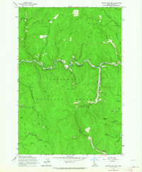
 1960 Elk City1960 Print · USGSThe Central Idaho wilderness and Bitterroot Range are captured here during the peak of mid-century industrial mining. Researchers can trace remote backcountry settlements like Burgdorf and Warren, alongside major mineral sites including the Blackbird Mine and Ima Mine.2 unique versions available
 - 1962 Map of Center Star Mtn, 1964 Print
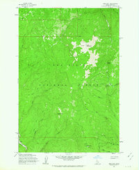
 1962 Center Star Mtn1964 Print · USGSThe Idaho backcountry in the early sixties reveals a landscape shaped by gold extraction and rugged transport routes. Researchers can trace the path of the Elk City Stage Road and locate numerous historic claims like the Center Star Mine and Coeur d'Alene Mine.4 unique versions available
 - 1962 Map of Iron Mtn, 1964 Print
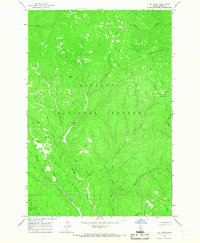
 1962 Iron Mtn1964 Print · USGSIdaho County's backcountry is captured here in the early 1960s, showing the intersection of forest management and early mining history. Researchers can trace the Dredge Tailings along the American River or locate remote stations like the Elk Summit Lookout.3 unique versions available
 - 1966 Map of Elk City, 1968 Print
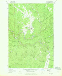 1966 Elk City1968 Print · USGSElk City and its surrounding gold-mining district are captured here in the mid-1960s when dredging and deep-shaft mining still defined the landscape. Researchers can locate specific legacy operations like the Sultan Shaft and Buster Mine or trace the old City Stage Road.3 unique versions available
 - 1966 Map of Lick Point, 1968 Print
 1966 Lick Point1968 Print · USGSDeep in the Nez Perce National Forest during the mid-1960s, this area showcases the intersection of industrial mining and the Idaho wilderness. Researchers can trace the legacy of resource extraction through the Dredge and Tailings found along the American River.2 unique versions available
End of results
Showing maps 1-5 of 5
Frequently asked questions
- What are the different types of historical maps available for Elk City?
- What is the oldest map of Elk City?
- Where can I purchase historical maps of Elk City for my home or office?
- Where can I download high-res historical maps of Elk City?
- Are there historical topographic maps available for Elk City?
- Is there historical aerial imagery available for Elk City?
- Where are historical maps of Elk City sourced from?