1960s Maps of Harpster, Idaho
Explore 2 historic maps of Harpster from the 1960s. These maps offer a rare glimpse into what life looked like during the 1960s — showing old roads, neighborhoods, homes, and landmarks that have changed or disappeared over time.
Whether you're researching your family's past, planning a metal detecting trip, or studying how Harpster's landscape evolved across the 1960s, these high-resolution maps are a powerful tool for exploring the history of this region.
- Focus on a specific era: All maps on this page are from the 1960s, giving you a focused view of this time period.
- See what’s changed: Compare century-old streets, trails, and buildings to today's modern landscape using overlays and satellite layers.
- Research with precision: Use these maps for genealogy, historical research, land use analysis, or educational projects.
- View, download, or print: Maps are fully viewable online in high resolution, and can be downloaded or printed for your own records.
Start exploring Harpster's history through authentic maps from the 1960s. This is your window into the past.
Harpster, ID maps
(2)- 1960 Map of Elk City
 1960 Elk City1960 Print · USGSThe Central Idaho wilderness and Bitterroot Range are captured here during the peak of mid-century industrial mining. Researchers can trace remote backcountry settlements like Burgdorf and Warren, alongside major mineral sites including the Blackbird Mine and Ima Mine.2 unique versions available
 - 1963 Map of Harpster, 1965 Print
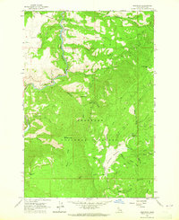 1963 Harpster1965 Print · USGSIdaho's river canyons and timberlands are captured here in the early sixties, centered on the settlement of Harpster along the South Fork Clearwater River. Researchers can trace old mountain routes like the jeep trails leading to McComas Meadows, Camp 58, and Monument Hill.
End of results
Showing maps 1-2 of 2
Top cities near Harpster
Frequently asked questions
- What are the different types of historical maps available for Harpster?
- What is the oldest map of Harpster?
- Where can I purchase historical maps of Harpster for my home or office?
- Where can I download high-res historical maps of Harpster?
- Are there historical topographic maps available for Harpster?
- Is there historical aerial imagery available for Harpster?
- Where are historical maps of Harpster sourced from?