1900s (20th Century) Maps of Warren, Idaho
Explore 5 historic maps of Warren from the 1900s (20th Century). These maps offer a rare glimpse into what life looked like during the 1900s — showing old roads, neighborhoods, homes, and landmarks that have changed or disappeared over time.
Whether you're researching your family's past, planning a metal detecting trip, or studying how Warren's landscape evolved across the 1900s, these high-resolution maps are a powerful tool for exploring the history of this region.
- Focus on a specific era: All maps on this page are from the 1900s, giving you a focused view of this time period.
- See what’s changed: Compare century-old streets, trails, and buildings to today's modern landscape using overlays and satellite layers.
- Research with precision: Use these maps for genealogy, historical research, land use analysis, or educational projects.
- View, download, or print: Maps are fully viewable online in high resolution, and can be downloaded or printed for your own records.
Start exploring Warren's history through authentic maps from the 1900s. This is your window into the past.
Warren, ID maps
(5)- 1956 Map of Warren, 1957 Print
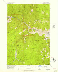 1956 Warren1957 Print · USGSRemote Idaho gold mining camps and wilderness ranches appear in this mid-fifties survey of the Salmon River canyon. Genealogists and researchers can trace the isolated Shep Ranch, the riverside Mackay Bar, and historic mining operations like the War Eagle Mine.3 unique versions available
 - 1956 Map of Elk City, 1963 Print
 1956 Elk City1963 Print · USGSThe Idaho backcountry in the mid-fifties remains a landscape of isolated mining camps and remote forest outposts. Researchers can trace historical mining operations at Stibnite Mine and Blackbird Mine or locate riverside landmarks like Mackay Bar and Campbell's Ferry.3 unique versions available
 - 1960 Map of Elk City
 1960 Elk City1960 Print · USGSThe Central Idaho wilderness and Bitterroot Range are captured here during the peak of mid-century industrial mining. Researchers can trace remote backcountry settlements like Burgdorf and Warren, alongside major mineral sites including the Blackbird Mine and Ima Mine.2 unique versions available
 - 1981 Map of Warren
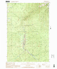
 1981 Warren1981 Print · USGSCentral Idaho’s high backcountry is revealed here in the early eighties, where isolated mining camps and wilderness boundaries met. Genealogists and historians can trace old claims like the Czizek Mine and Red Metals Mine or the remote outpost of Edwardsburg.
 - 1989 Map of Warren, 1990 Print
 1989 Warren1990 Print · USGSIdaho’s high-country mining legacy is on full display in the late eighties near Warren, where the landscape is etched by decades of creek-side operations. You can trace the Warren Wagon Road, locate the Mitchell Guard Station, and find numerous tailings sites.2 unique versions available
End of results
Showing maps 1-5 of 5
Frequently asked questions
- What are the different types of historical maps available for Warren?
- What is the oldest map of Warren?
- Where can I purchase historical maps of Warren for my home or office?
- Where can I download high-res historical maps of Warren?
- Are there historical topographic maps available for Warren?
- Is there historical aerial imagery available for Warren?
- Where are historical maps of Warren sourced from?