1950s Maps of Kootenai County, Idaho
Explore 15 historic maps of Kootenai County from the 1950s. These maps offer a rare glimpse into what life looked like during the 1950s — showing old roads, neighborhoods, homes, and landmarks that have changed or disappeared over time.
Whether you're researching your family's past, planning a metal detecting trip, or studying how Kootenai County's landscape evolved across the 1950s, these high-resolution maps are a powerful tool for exploring the history of this region.
- Focus on a specific era: All maps on this page are from the 1950s, giving you a focused view of this time period.
- See what’s changed: Compare century-old streets, trails, and buildings to today's modern landscape using overlays and satellite layers.
- Research with precision: Use these maps for genealogy, historical research, land use analysis, or educational projects.
- View, download, or print: Maps are fully viewable online in high resolution, and can be downloaded or printed for your own records.
Start exploring Kootenai County's history through authentic maps from the 1950s. This is your window into the past.
Kootenai County, ID maps
(15)- 1950 Map of Mt Spokane, 1952 Print
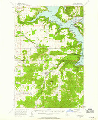
 1950 Mt Spokane1952 Print · USGSThe Washington-Idaho borderlands in the early fifties reveal a landscape of high summits and quiet lake basins. Genealogists and local historians can trace rural school districts like Kit Carson School and small community hubs such as Inland Grange and Peone.3 unique versions available
 - 1950 Map of Rochat Peak, 1976 Print
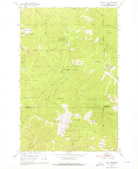 1950 Rochat Peak1976 Print · USGSNorthern Idaho's high country is captured here during the mid-century, showing the overlapping boundaries of tribal lands and national forests. Researchers can trace the Former Boundary Coeur d'Alene Indian Reservation and locate remote landmarks like Eagle Lookout and Rochat Peak.2 unique versions available
 - 1950 Map of Twin Crags, 1980 Print
 1950 Twin Crags1980 Print · USGSThe high Idaho ridges of Shoshone and Kootenai counties are captured here in the early 1950s, showing a landscape of lookouts and mining claims. Trace the reach of the Palisade Mine, locate the high Frost Peak Lookout, and follow the many forks of Pine Creek.
 - 1951 Map of Greenacres
 1951 Greenacres1951 Print · USGSThe Spokane Valley at the mid-century shows a busy corridor of rail lines and new post-war industry. Researchers can trace family roots at Saltese Cem, explore the early footprint of the Naval Supply Depot, or locate vanished stations along the Spokane International railroad.2 unique versions available
 - 1952 Map of Rochat Peak
 1952 Rochat Peak1952 Print · USGSNorthern Idaho's high timberlands and the Coeur D'Alene Indian Reservation are documented here in the early fifties. Local historians can trace the Former Boundary or locate remote landmarks like Eagle Lookout and Crystal Lake.
 - 1952 Map of Twin Crags
 1952 Twin Crags1952 Print · USGSHigh peaks and mining claims define this Shoshone County wilderness in the early fifties, where the national forest boundaries meet at the St Joe Divide. Local historians can trace the geography of early industry at the Palisade Mine and the timbered basins of Pine Creek.
 - 1954 Map of Fairfield, 1956 Print
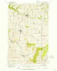 1954 Fairfield1956 Print · USGSEastern Washington's agricultural heartland is documented here in the mid-fifties, featuring a dense network of rail lines and grain-country settlements. Trace the routes of the Union Pacific and visit sites like Fairfield, Latah, and the McIntosh Grange.3 unique versions available
 - 1955 Map of Spokane, 1965 Print
 1955 Spokane1965 Print · USGSInland Empire life in the fifties and sixties centers on the growth of Spokane and the heavy mining industry of northern Idaho. Trace mid-century landmarks like Fairchild Air Force Base, the Bunker Hill Mine, and early campuses such as Gonzaga University.2 unique versions available
 - 1957 Map of St. Maries, 1958 Print
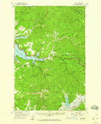
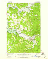 1957 St. Maries1958 Print · USGSThe St. Joe and Coeur d'Alene river valleys come alive in the late fifties, showing a landscape defined by timber, rail, and water. Genealogists can locate St Maries, Harrison, and rural landmarks like the Ramy Hill Guard Sta.3 unique versions available
 - 1957 Map of Kingston, 1959 Print
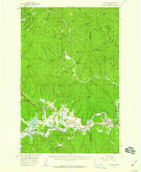 1957 Kingston1959 Print · USGSThe river valley between Kootenai and Shoshone counties is captured here in the late fifties, showing the vital transport links along the Coeur d'Alene River. Researchers can trace local landmarks like the Cataldo Mission, Canyon School, and the Union Pacific Railroad line.3 unique versions available
 - 1957 Map of Plummer, 1959 Print
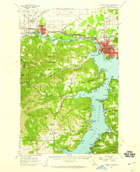
 1957 Plummer1959 Print · USGSSouthern Coeur d'Alene Lake and the surrounding timberlands are captured here in the mid-fifties, showing the intersection of lake life and rail industry. Researchers can trace the Milwaukee Road through the Sorrento Tunnel or locate historic sites in Heyburn State Park and Harrison.2 unique versions available
 - 1957 Map of Coeur D'Alene, 1959 Print
 1957 Coeur D'Alene1959 Print · USGSCoeur d'Alene and the Spokane River are captured here in the late fifties, showing a bustling landscape of timber mills and rail junctions. Researchers can trace the lines of the Great Northern railroad through Grand Junction or locate family sites near Evergreen Cemetery and Cloverleaf Grange.2 unique versions available
 - 1957 Map of Lane, 1960 Print
 1957 Lane1960 Print · USGSThe eastern shores of Coeur d'Alene Lake and the surrounding national forest are captured here in the mid-fifties. Genealogists and local historians can trace the Union Pacific rail corridor through Lane, find old mining sites like the Caribou Mine, and locate the Mullan Tree Historic Site.2 unique versions available
 - 1957 Map of St. Joe, 1960 Print
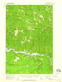 1957 St. Joe1960 Print · USGSThe St. Joe River valley was a hub of rail and river activity in the late fifties, dominated by the timber and mining industries. Researchers can trace the path of the Chicago Milwaukee St Paul and Pacific Road past Omega and the Palisade Mine.3 unique versions available
 - 1958 Map of Spokane
 1958 Spokane1958 Print · USGSThe Inland Empire is shown at a mid-century peak of industrial and military activity, from the rail hubs of Spokane to the deep silver mines of northern Idaho. Researchers can trace the sprawling rail lines of the Union Pacific RR or locate landmarks like Fairchild Air Force Base and the Bunker Hill Smelter & Mine.
End of results
Showing maps 1-15 of 15
Top cities of Kootenai County
- Coeur d'Alene historical maps
- Post Falls historical maps
- Hayden historical maps
- Rathdrum historical maps
- Dalton Gardens historical maps
- Spirit Lake historical maps
See more
Frequently asked questions
- What are the different types of historical maps available for Kootenai County?
- What is the oldest map of Kootenai County?
- Where can I purchase historical maps of Kootenai County for my home or office?
- Where can I download high-res historical maps of Kootenai County?
- Are there historical topographic maps available for Kootenai County?
- Is there historical aerial imagery available for Kootenai County?
- Where are historical maps of Kootenai County sourced from?