1980s Maps of Dalton Gardens, Idaho
Explore 3 historic maps of Dalton Gardens from the 1980s. These maps offer a rare glimpse into what life looked like during the 1980s — showing old roads, neighborhoods, homes, and landmarks that have changed or disappeared over time.
Whether you're researching your family's past, planning a metal detecting trip, or studying how Dalton Gardens's landscape evolved across the 1980s, these high-resolution maps are a powerful tool for exploring the history of this region.
- Focus on a specific era: All maps on this page are from the 1980s, giving you a focused view of this time period.
- See what’s changed: Compare century-old streets, trails, and buildings to today's modern landscape using overlays and satellite layers.
- Research with precision: Use these maps for genealogy, historical research, land use analysis, or educational projects.
- View, download, or print: Maps are fully viewable online in high resolution, and can be downloaded or printed for your own records.
Start exploring Dalton Gardens's history through authentic maps from the 1980s. This is your window into the past.
Dalton Gardens, ID maps
(3)- 1981 Map of Fernan Lake
 1981 Fernan Lake1981 Print · USGSCoastal life and rugged forest boundaries meet here in the early eighties. Genealogists and historians can trace the routes of the Mullan Trail and Yellowstone Trail as they pass Fernan Lake Village and the shores of Bennett Bay.2 unique versions available
 - 1981 Map of Coeur D'Alene, 1982 Print
 1981 Coeur D'Alene1982 Print · USGSThe northern shores of Coeur d'Alene Lake are captured here in the early eighties, showcasing a period of significant regional development. Researchers can trace historic cemeteries such as Forest Cem and St Thomas Cem or locate old industrial sites near Huetter.2 unique versions available
 - 1987 Map of Coeur D'Alene
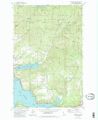
 1987 Coeur D'Alene1987 Print · USGSNorthern Idaho in the late eighties shows a landscape of deep-water lakes and heavy industry where the timber and mining economies meet growing valley settlements. Genealogists and historians can trace the footprints of the Sunshine Mine, the rail sidings at Corbin Junction, and the historic Old Mission State Park.3 unique versions available
End of results
Showing maps 1-3 of 3
Top cities near Dalton Gardens
- Coeur d'Alene historical maps
- Post Falls historical maps
- Hayden historical maps
- Rathdrum historical maps
- Spirit Lake historical maps
- Athol historical maps
See more
Frequently asked questions
- What are the different types of historical maps available for Dalton Gardens?
- What is the oldest map of Dalton Gardens?
- Where can I purchase historical maps of Dalton Gardens for my home or office?
- Where can I download high-res historical maps of Dalton Gardens?
- Are there historical topographic maps available for Dalton Gardens?
- Is there historical aerial imagery available for Dalton Gardens?
- Where are historical maps of Dalton Gardens sourced from?