1980s Maps of Post Falls, Idaho
Explore 4 historic maps of Post Falls from the 1980s. These maps offer a rare glimpse into what life looked like during the 1980s — showing old roads, neighborhoods, homes, and landmarks that have changed or disappeared over time.
Whether you're researching your family's past, planning a metal detecting trip, or studying how Post Falls's landscape evolved across the 1980s, these high-resolution maps are a powerful tool for exploring the history of this region.
- Focus on a specific era: All maps on this page are from the 1980s, giving you a focused view of this time period.
- See what’s changed: Compare century-old streets, trails, and buildings to today's modern landscape using overlays and satellite layers.
- Research with precision: Use these maps for genealogy, historical research, land use analysis, or educational projects.
- View, download, or print: Maps are fully viewable online in high resolution, and can be downloaded or printed for your own records.
Start exploring Post Falls's history through authentic maps from the 1980s. This is your window into the past.
Post Falls, ID maps
(4)- 1981 Map of Coeur D'Alene, 1982 Print
 1981 Coeur D'Alene1982 Print · USGSThe northern shores of Coeur d'Alene Lake are captured here in the early eighties, showcasing a period of significant regional development. Researchers can trace historic cemeteries such as Forest Cem and St Thomas Cem or locate old industrial sites near Huetter.2 unique versions available
 - 1981 Map of Post Falls, 1982 Print
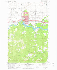 1981 Post Falls1982 Print · USGSPost Falls and the Spokane River are captured here in the early eighties as industrial growth and suburban expansion began to reshape the Idaho landscape. Genealogists and local historians can trace the foundations of the community through landmarks like Evergreen Cemetery, Seltice Sch, and the rail junction at McGuire.2 unique versions available
 - 1987 Map of Spokane
 1987 Spokane1987 Print · USGSGreater Spokane and its surrounding prairies are captured in the late 1980s as the region solidified its role as a regional hub. Researchers can trace family sites near Medical Lake, military life at Fairchild Air Force Base, and rural settlements like Peone and Chattaroy.
 - 1987 Map of Coeur D'Alene
 1987 Coeur D'Alene1987 Print · USGSNorthern Idaho in the late eighties shows a landscape of deep-water lakes and heavy industry where the timber and mining economies meet growing valley settlements. Genealogists and historians can trace the footprints of the Sunshine Mine, the rail sidings at Corbin Junction, and the historic Old Mission State Park.3 unique versions available
End of results
Showing maps 1-4 of 4
Top cities near Post Falls
- Spokane Valley historical maps
- Coeur d'Alene historical maps
- Hayden historical maps
- Liberty Lake historical maps
- Rathdrum historical maps
- Dalton Gardens historical maps
See more
Top neighborhoods of Post Falls
Frequently asked questions
- What are the different types of historical maps available for Post Falls?
- What is the oldest map of Post Falls?
- Where can I purchase historical maps of Post Falls for my home or office?
- Where can I download high-res historical maps of Post Falls?
- Are there historical topographic maps available for Post Falls?
- Is there historical aerial imagery available for Post Falls?
- Where are historical maps of Post Falls sourced from?