1990s Maps of Lewis County, Idaho
Explore 4 historic maps of Lewis County from the 1990s. These maps offer a rare glimpse into what life looked like during the 1990s — showing old roads, neighborhoods, homes, and landmarks that have changed or disappeared over time.
Whether you're researching your family's past, planning a metal detecting trip, or studying how Lewis County's landscape evolved across the 1990s, these high-resolution maps are a powerful tool for exploring the history of this region.
- Focus on a specific era: All maps on this page are from the 1990s, giving you a focused view of this time period.
- See what’s changed: Compare century-old streets, trails, and buildings to today's modern landscape using overlays and satellite layers.
- Research with precision: Use these maps for genealogy, historical research, land use analysis, or educational projects.
- View, download, or print: Maps are fully viewable online in high resolution, and can be downloaded or printed for your own records.
Start exploring Lewis County's history through authentic maps from the 1990s. This is your window into the past.
Lewis County, ID maps
(4)- 1994 Map of Sixmile Creek, 1997 Print
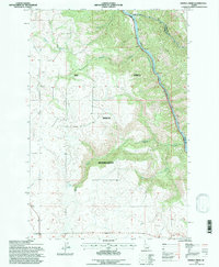 1994 Sixmile Creek1997 Print · USGSThe northern reaches of the Nez Perce Indian Reservation are captured here in the mid-1990s as the landscape transitions toward the canyon floor. Researchers can trace the rugged drainage systems of Sixmile Creek and Fivemile Creek or locate local resource sites like the Gravel Pit.
 - 1994 Map of Orofino West, 1997 Print
 1994 Orofino West1997 Print · USGSIn the mid-1990s, the confluence of the Clearwater and its North Fork remained the vital heart of this Idaho river valley. Researchers can trace the path of the Camas Prairie Railroad and locate local landmarks like Gilbert Ch and Central Ridge Cem.
 - 1994 Map of Orofino East, 1997 Print
 1994 Orofino East1997 Print · USGSThe Clearwater River valley and the Nez Perce Indian Reservation are shown in detail during the mid-1990s. Genealogists and local historians can trace the Lewis and Clark National Historic Trail or locate landmarks like the Cem near Fraser and the Gilbert Grade.
 - 1994 Map of Woodland, 1998 Print
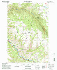 1994 Woodland1998 Print · USGSUpper Idaho's plateaus and deep river canyons are captured here in the mid-1990s, showcasing the high-country landscape near the Nez Perce Indian Reservation. You can trace historical routes like the Lewis and Clark National Historic Trail and locate small upland settlements like Woodland and Harrisburg.
End of results
Showing maps 1-4 of 4
Top cities of Lewis County
Frequently asked questions
- What are the different types of historical maps available for Lewis County?
- What is the oldest map of Lewis County?
- Where can I purchase historical maps of Lewis County for my home or office?
- Where can I download high-res historical maps of Lewis County?
- Are there historical topographic maps available for Lewis County?
- Is there historical aerial imagery available for Lewis County?
- Where are historical maps of Lewis County sourced from?