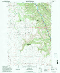
1994 Map of Sixmile Creek
USGS Topo · Published 1997About this map
Nez Perce Indian Reservation territory defines the majority of this landscape, where the high plateaus are carved by deep drainages flowing toward the Clearwater River. Along the northeastern edge, the river serves as a prominent natural and political boundary between Lewis Co and Idaho Co, carrying water from numerous interior tributaries. The topographical layout is characterized by significant elevation changes, with Sixmile Creek and Fivemile Creek cutting through the terrain. Small-scale industrial activity is evidenced by scattered extractions such as the Gravel Pit and Borrow Pit, while the lower reaches of Effie Creek demonstrate the complex network of seasonal and perennial streams that define this part of the Idaho backcountry.
Find a feature on this map
8 named features on this map. Tap any name to fly to it.
Don’t see what you’re looking for? This feature index may not catch every label — zoom into the map to look around manually.
Map Details
Editions of this 1994 Sixmile Creek Map
This is the sole edition of this map. No revisions or reprints were ever made.
Other maps of this area

1924 · Kamiah
USGS Topo · 1:125,000

1955 · Pullman
USGS Topo · 1:250,000

1958 · Pullman
USGS Topo · 1:250,000

1967 · Mohler
USGS Topo · 1:24,000
1967 · Kamiah
USGS Topo · 1:24,000

1967 · Sixmile Creek
USGS Topo · 1:24,000

1967 · Rudo
USGS Topo · 1:24,000

1967 · Cottonwood NE
USGS Topo · 1:24,000

1967 · Orofino West
USGS Topo · 1:24,000
1967 · Nezperce
USGS Topo · 1:24,000