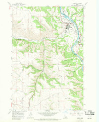
1967 Map of Kamiah
USGS Topo · Published 1971About this map
Kamiah sits at a strategic bend where Lawyer Creek meets the Clearwater River, serving as a central hub for the surrounding plateau and river valley in the late 1960s. The landscape is defined by the sharp transition from the river bottom to the high Camas Prairie, navigated by steep routes like the Woodland Grade. This survey highlights the deep cultural roots of the area, notably within the Nez Perce Historical Park and several local burial grounds including Teh La Pa Low Cem and Nikesa Cem. Settlement patterns follow both the water and the heights, with East Kamiah across the river and the community of Winona positioned near the western edge of the sheet. Industrial and transport infrastructure, from the Kamiah Airport to the Tram Road and local Gravel Pits, reflect the region's mid-century economic activities.
Find a feature on this map
28 named features on this map. Tap any name to fly to it.
Don’t see what you’re looking for? This feature index may not catch every label — zoom into the map to look around manually.
Map Details
Editions of this 1967 Kamiah Map
2 editions found
Other maps of this area

1924 · Kamiah
USGS Topo · 1:125,000

1924 · Weippe
USGS Topo · 1:125,000

1955 · Pullman
USGS Topo · 1:250,000

1956 · Hamilton
USGS Topo · 1:250,000

1958 · Pullman
USGS Topo · 1:250,000

1959 · Hamilton
USGS Topo · 1:250,000

1960 · Hamilton
USGS Topo · 1:250,000

1964 · Hamilton
USGS Topo · 1:250,000

1966 · Kooskia
USGS Topo · 1:24,000
1966 · Stites
USGS Topo · 1:24,000