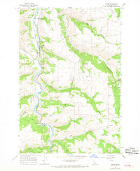
1966 Map of Stites
USGS Topo · Published 1968About this map
The South Fork Clearwater River winds through a landscape defined by dramatic elevation changes and historical conflict, centered on the town of Stites. This mid-century survey captures the community just north of the Clearwater Battlefield Site, a significant landmark within the Nez Perce Indian Reservation Boundary. The settlement of Stites serves as a local hub, featuring a Gaging Station, Water Tanks, and a Sewage Disposal plant, reflecting mid-century infrastructure developments in Idaho County.
Find a feature on this map
36 named features on this map. Tap any name to fly to it.
Don’t see what you’re looking for? This feature index may not catch every label — zoom into the map to look around manually.
Map Details
Editions of this 1966 Stites Map
2 editions found
Other maps of this area

1924 · Kamiah
USGS Topo · 1:125,000

1924 · Weippe
USGS Topo · 1:125,000

1931 · Buffalo Hump
USGS Topo · 1:125,000

1934 · Buffalo Hump
USGS Topo · 1:125,000

1955 · Pullman
USGS Topo · 1:250,000

1955 · Grangeville
USGS Topo · 1:250,000

1956 · Elk City
USGS Topo · 1:250,000

1956 · Hamilton
USGS Topo · 1:250,000

1958 · Pullman
USGS Topo · 1:250,000

1959 · Grangeville
USGS Topo · 1:250,000