
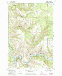
1966 Map of Kooskia
USGS Topo · Published 1968About this map
The Nez Perce Indian Reservation defines the northern reaches of this Idaho landscape, where the confluence of major river forks shapes the settlement patterns near Kooskia. The town sits at the junction of the South Fork Clearwater River and the Middle Fork Clearwater River, serving as a focal point for infrastructure like the Kooskia National Fish Hatchery and local utilities including sewage disposal ponds and several Water Tanks. The surrounding ridges, such as Kidder Ridge and Harris Ridge, are marked by agricultural and pastoral development, indicated by numerous springs and fence lines. Genealogists will find significant value in the distribution of burial sites across the terrain, including Grandview Cem, Miller Cem, Nicodemus Cem, and Pine Grove Cem, alongside the Kidder site and Nikesa Church.
Find a feature on this map
34 named features on this map. Tap any name to fly to it.
Don’t see what you’re looking for? This feature index may not catch every label — zoom into the map to look around manually.
Map Details
Editions of this 1966 Kooskia Map
2 editions found
Other maps of this area

1924 · Kamiah
USGS Topo · 1:125,000

1924 · Weippe
USGS Topo · 1:125,000

1955 · Pullman
USGS Topo · 1:250,000

1956 · Hamilton
USGS Topo · 1:250,000

1958 · Pullman
USGS Topo · 1:250,000

1959 · Hamilton
USGS Topo · 1:250,000

1960 · Hamilton
USGS Topo · 1:250,000

1964 · Hamilton
USGS Topo · 1:250,000
1966 · Stites
USGS Topo · 1:24,000
1966 · Big Cedar
USGS Topo · 1:24,000