
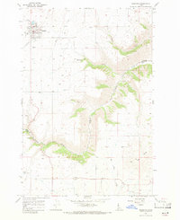
1967 Map of Mohler
USGS Topo · Published 1971About this map
Mohler sits as a primary settlement in this late 1960s landscape, positioned where the high plains of Central Ridge begin their descent into a complex system of drainage coulees. The terrain is defined by the deep incisions of Big Canyon Creek and Little Canyon Creek, which carve steep-walled valleys through the agricultural plateau. Small-scale industrial activity is evident near the watercourses, with several Gravel Pits and operations located along the creek beds, particularly near Long Hollow Creek. Evidence of early territorial organization is present through the visible Boise Meridian and the Nez Perce and Lewis County boundary. Genealogists may find interest in the Russell Cem located in the northeast, while the smaller settlement of Graves and various segments of Jeep Trail suggest the rural connectivity of this interior Idaho region during the mid-century era.
Find a feature on this map
13 named features on this map. Tap any name to fly to it.
Don’t see what you’re looking for? This feature index may not catch every label — zoom into the map to look around manually.
Map Details
Editions of this 1967 Mohler Map
This is the sole edition of this map. No revisions or reprints were ever made.
Other maps of this area

1924 · Kamiah
USGS Topo · 1:125,000

1955 · Pullman
USGS Topo · 1:250,000

1958 · Pullman
USGS Topo · 1:250,000

1967 · Fletcher
USGS Topo · 1:24,000

1967 · Craigmont
USGS Topo · 1:24,000

1967 · Sixmile Creek
USGS Topo · 1:24,000

1967 · Cottonwood NE
USGS Topo · 1:24,000

1967 · Peck
USGS Topo · 1:24,000

1967 · Orofino West
USGS Topo · 1:24,000
1967 · Nezperce
USGS Topo · 1:24,000