1940s Maps of Madison County, Idaho
Explore 7 historic maps of Madison County from the 1940s. These maps offer a rare glimpse into what life looked like during the 1940s — showing old roads, neighborhoods, homes, and landmarks that have changed or disappeared over time.
Whether you're researching your family's past, planning a metal detecting trip, or studying how Madison County's landscape evolved across the 1940s, these high-resolution maps are a powerful tool for exploring the history of this region.
- Focus on a specific era: All maps on this page are from the 1940s, giving you a focused view of this time period.
- See what’s changed: Compare century-old streets, trails, and buildings to today's modern landscape using overlays and satellite layers.
- Research with precision: Use these maps for genealogy, historical research, land use analysis, or educational projects.
- View, download, or print: Maps are fully viewable online in high resolution, and can be downloaded or printed for your own records.
Start exploring Madison County's history through authentic maps from the 1940s. This is your window into the past.
Madison County, ID maps
(7)- 1943 Map of Garns Mtn, 1957 Print
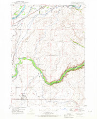
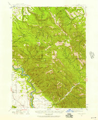 1943 Garns Mtn1957 Print · USGSEastern Idaho's high ridges and the winding Snake River corridor are captured here during the mid-1940s. Researchers can locate remote industrial sites like the Brown Bear Mine, early education landmarks such as the Upper Pine Creek Sch, and the Durrant Ranch.3 unique versions available
 - 1946 Map of Garns Mtn
 1946 Garns Mtn1946 Print · USGSHigh-country ranching and coal mining define this Idaho landscape in the 1940s, situated where the Snake River meets the Big Flat. Genealogists and historians can trace family locations at the Durant Ranch or follow the local mining economy through sites like the Mikesell Mine and Pintar Mine.
 - 1948 Map of Rigby, 1959 Print
 1948 Rigby1959 Print · USGSThe Upper Snake River Valley comes to life in this post-war survey, showing the agricultural engine of Jefferson County. Genealogists and local historians can trace the irrigation network through dozens of named features like the Rigby Canal or locate landmarks such as Garfield Sch and the Little Buttes.
 - 1948 Map of Parker, 1973 Print
 1948 Parker1973 Print · USGSFremont and Madison counties are captured here just after the war, showing the intensive irrigation and rail network of the upper Snake River Valley. Trace family roots and land use near Parker, Salem, and the Fort Henry Historic Monument.2 unique versions available
 - 1949 Map of Rexburg
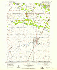
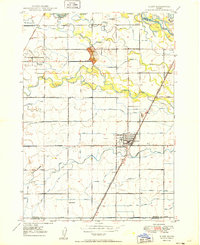
 1949 Rexburg1949 Print · USGSThe Madison County landscape was defined by its irrigation networks and the growing influence of Rexburg in the late 1940s. Genealogists and historians can trace family-named landmarks and essential community sites like Ricks College, Thornton, and Burton Cem.4 unique versions available
 - 1949 Map of Rigby
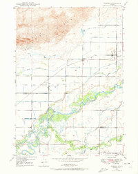
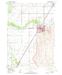
 1949 Rigby1949 Print · USGSJefferson County in the late 1940s is defined by a massive irrigation network surrounding Rigby and Menan. Genealogists and historians can trace the paths of the Union Pacific, locate the Garfield Sch, and study the complex system of the Burgess Canal.3 unique versions available
 - 1949 Map of Newdale, 1966 Print
 1949 Newdale1966 Print · USGSSoutheast Idaho at the end of the 1940s is defined by a intricate network of irrigation and rail. Researchers can trace the agricultural development around Chester and Newdale, following features like the Chester Cem, the Union Pacific line, and the deep winding gorge of the Teton River.2 unique versions available
End of results
Showing maps 1-7 of 7
Top cities of Madison County
Frequently asked questions
- What are the different types of historical maps available for Madison County?
- What is the oldest map of Madison County?
- Where can I purchase historical maps of Madison County for my home or office?
- Where can I download high-res historical maps of Madison County?
- Are there historical topographic maps available for Madison County?
- Is there historical aerial imagery available for Madison County?
- Where are historical maps of Madison County sourced from?