1940s Maps of Bruneau, Idaho
Explore 3 historic maps of Bruneau from the 1940s. These maps offer a rare glimpse into what life looked like during the 1940s — showing old roads, neighborhoods, homes, and landmarks that have changed or disappeared over time.
Whether you're researching your family's past, planning a metal detecting trip, or studying how Bruneau's landscape evolved across the 1940s, these high-resolution maps are a powerful tool for exploring the history of this region.
- Focus on a specific era: All maps on this page are from the 1940s, giving you a focused view of this time period.
- See what’s changed: Compare century-old streets, trails, and buildings to today's modern landscape using overlays and satellite layers.
- Research with precision: Use these maps for genealogy, historical research, land use analysis, or educational projects.
- View, download, or print: Maps are fully viewable online in high resolution, and can be downloaded or printed for your own records.
Start exploring Bruneau's history through authentic maps from the 1940s. This is your window into the past.
Bruneau, ID maps
(3)- 1947 Map of Bruneau, 1952 Print
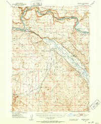 1947 Bruneau1952 Print · USGSThe confluence of the Snake and Bruneau Rivers in the late 1940s reveals a rugged landscape defined by pioneer history and modern irrigation. Researchers can trace the Emigrant Trail to the Halls Ferry (Site) and locate landmarks like the Little Valley Sch (Aban'd) and ancient Petroglyphs.2 unique versions available
 - 1947 Map of Bruneau, 1968 Print
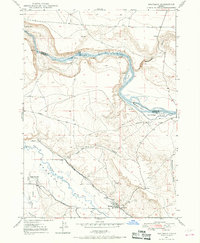 1947 Bruneau1968 Print · USGSThe Owyhee County desert meets the river canyons in the late 1940s, where pioneer history and irrigation agriculture overlap. Trace the historic Emigrant Trail down to the Emigrant Crossing and find the location of the Little Valley Sch (Aban'd).3 unique versions available
 - 1948 Map of Bruneau
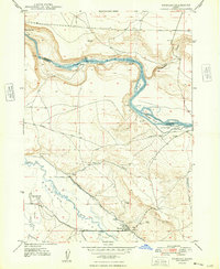 1948 Bruneau1948 Print · USGSOwyhee County's high-desert ranching and river landscape is captured here in the years following World War II. Researchers can trace the historic Emigrant Trail and locate local landmarks like the Little Valley Sch (Aban'd) and Crane Falls.
End of results
Showing maps 1-3 of 3
Top cities near Bruneau
Frequently asked questions
- What are the different types of historical maps available for Bruneau?
- What is the oldest map of Bruneau?
- Where can I purchase historical maps of Bruneau for my home or office?
- Where can I download high-res historical maps of Bruneau?
- Are there historical topographic maps available for Bruneau?
- Is there historical aerial imagery available for Bruneau?
- Where are historical maps of Bruneau sourced from?