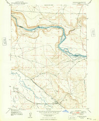
1948 Map of Bruneau
USGS Topo · Published 1948About this map
The confluence of the Snake River and the Bruneau River Valley defines this high-desert landscape in the late 1940s. Agriculture is anchored by the complex irrigation network of the South Side Canal and the Buckaroo Ditch, which support the settlement of Bruneau. Evidence of earlier western passage is clearly visible in the route of the Emigrant Trail cutting across the mesas. The map documents several sites no longer in primary use, such as the Little Valley Sch (Aban'd) and a Race Track (Aban'd) located just north of the town center. Deep river bends create distinctive features like Edgington Island and Loveridge Island, while dramatic landmarks such as Crane Falls mark the rugged descent of the Snake River through the canyon.
Find a feature on this map
25 named features on this map. Tap any name to fly to it.
Don’t see what you’re looking for? This feature index may not catch every label — zoom into the map to look around manually.
Map Details
Editions of this 1948 Bruneau Map
This is the sole edition of this map. No revisions or reprints were ever made.
Other maps of this area

1892 · Mountain Home
USGS Topo · 1:125,000

1893 · Mountain Home
USGS Topo · 1:125,000

1946 · Mouth of Bruneau
USGS Topo · 1:24,000

1947 · Little Valley
USGS Topo · 1:24,000

1947 · Bruneau
USGS Topo · 1:62,500

1947 · Sand Dunes
USGS Topo · 1:24,000

1947 · Bruneau
USGS Topo · 1:24,000

1947 · Sugar Valley
USGS Topo · 1:24,000

1947 · Hot Spring
USGS Topo · 1:24,000

1948 · Sand Dunes
USGS Topo · 1:24,000