Old Maps of Erlmo, Idaho for Hiking & Exploration
Hike through history with 11 historic maps of Erlmo. Explore old trails, ghost towns, and forgotten backroads — perfect for outdoor adventurers and local explorers.
- Rediscover forgotten places: Map out old mining camps, roads, and footpaths that no longer exist on modern maps.
- Layer with modern tools: Combine with LiDAR or satellite views to plan hikes through historical terrain.
- Made for exploration: Popular among hikers, overlanders, and local history lovers.
Use these maps to find adventure and explore the hidden past of Erlmo.
Erlmo, ID maps
(11)- 1955 Map of Spokane, 1965 Print
 1955 Spokane1965 Print · USGSInland Empire life in the fifties and sixties centers on the growth of Spokane and the heavy mining industry of northern Idaho. Trace mid-century landmarks like Fairchild Air Force Base, the Bunker Hill Mine, and early campuses such as Gonzaga University.2 unique versions available
 - 1957 Map of Calder, 1959 Print
 1957 Calder1959 Print · USGSThe St Joe River valley in the late fifties was a remote corridor of rail transport and forest management. Researchers can trace the path of the Chicago Milwaukee St Paul and Pacific railroad through Calder and Herrick, or locate former settlements like Masonia (Site).2 unique versions available
 - 1958 Map of Spokane
 1958 Spokane1958 Print · USGSThe Inland Empire is shown at a mid-century peak of industrial and military activity, from the rail hubs of Spokane to the deep silver mines of northern Idaho. Researchers can trace the sprawling rail lines of the Union Pacific RR or locate landmarks like Fairchild Air Force Base and the Bunker Hill Smelter & Mine.
 - 1981 Map of St Maries
 1981 St Maries1981 Print · USGSThe timber and rail hub of St. Maries is captured here in the early 1980s as the river-and-rail economy defined the Panhandle. Researchers can trace historic transport corridors including the Union Pacific tracks and remote landings along the St Joe River and Chatcolet Lake.2 unique versions available
 - 1988 Map of Marble Creek
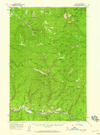
 1988 Marble Creek1988 Print · USGSThe St. Joe River valley in the late twentieth century reveals a landscape shaped by rail history and forest management. Researchers can trace the Old RR Grade near Herrick and locate historic recreational spots like the CCC Campground.
 - 1995 Map of Marble Creek, 1997 Print
 1995 Marble Creek1997 Print · USGSThe St Joe River corridor in the mid-1990s reveals a landscape shaped by timber and topography within the St Joe National Forest. Genealogists and historians can trace the Old RR Grade through Herrick or find named landmarks like Cemetery Ridge and Big Creek Cabin.
 - 2011 Map of Marble Creek, 2011 Print
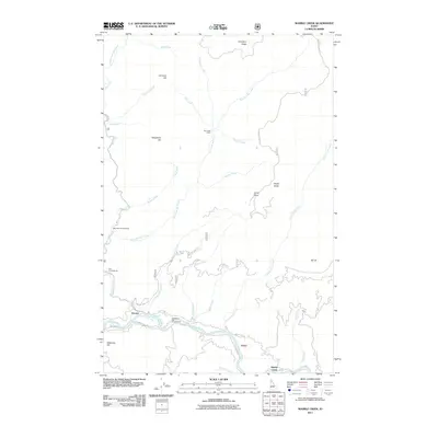 2011 Marble Creek2011 Print · USGSCovers Erlmo, including Herrick, Marble Creek, and other nearby areas
 - 2013 Map of Marble Creek, 2013 Print
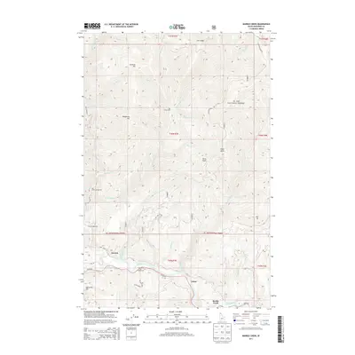 2013 Marble Creek2013 Print · USGSCovers Erlmo, including Herrick, Marble Creek, and other nearby areas
 - 2017 Map of Marble Creek, 2017 Print
 2017 Marble Creek2017 Print · USGSCovers Erlmo, including Herrick, Marble Creek, and other nearby areas
 - 2020 Map of Marble Creek, 2020 Print
 2020 Marble Creek2020 Print · USGSCovers Erlmo, including Herrick, Marble Creek, and other nearby areas
 - 2024 Map of Marble Creek, 2024 Print
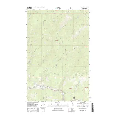
 2024 Marble Creek2024 Print · USGSShoshone County is captured here in the contemporary era, centered on the historic Saint Joe River corridor. Researchers can locate small riverside settlements like Herrick and Erlmo or trace the path of the Old Milwaukee Road RR Grade.
End of results
Showing maps 1-11 of 11
Top cities near Erlmo
Frequently asked questions
- What are the different types of historical maps available for Erlmo?
- What is the oldest map of Erlmo?
- Where can I purchase historical maps of Erlmo for my home or office?
- Where can I download high-res historical maps of Erlmo?
- Are there historical topographic maps available for Erlmo?
- Is there historical aerial imagery available for Erlmo?
- Where are historical maps of Erlmo sourced from?