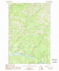
1988 Map of Marble Creek
USGS Topo · Published 1988About this map
The St Joe River winds through the southern portion of this landscape, flanked by the settlement of Herrick and evidence of the region's logging and transit history. The presence of an Old RR Grade running parallel to the river and another RR Grade further south indicates the vital role of rail transport in extracting resources from the St Joe National Forest. This 1980s survey captures a transition in forest use, where former industrial infrastructure sits alongside recreational sites like the CCC Campground and Huckleberry Flat Campground. The terrain is defined by prominent high points such as Cemetery Ridge, Sheep Butte, and Maternity Hill. A complex network of drainage basins, including Cameron Creek, Rogers Creek, and Agatha Creek, feeds into the main river system, illustrating the watershed's rugged geography.
Find a feature on this map
37 named features on this map. Tap any name to fly to it.
Don’t see what you’re looking for? This feature index may not catch every label — zoom into the map to look around manually.
Map Details
Editions of this 1988 Marble Creek Map
This is the sole edition of this map. No revisions or reprints were ever made.
Other maps of this area

1914 · Avery
USGS Topo · 1:125,000

1917 · Avery
USGS Topo · 1:125,000

1955 · Spokane
USGS Topo · 1:250,000

1956 · Wallace
USGS Topo · 1:250,000

1957 · Wallace
USGS Topo · 1:62,500

1957 · Calder
USGS Topo · 1:62,500

1958 · Spokane
USGS Topo · 1:250,000

1960 · Wallace
USGS Topo · 1:250,000

1969 · Marble Mountain
USGS Topo · 1:24,000
1969 · Hoyt Mountain
USGS Topo · 1:24,000