
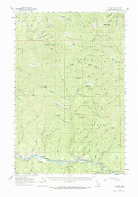
1957 Map of Calder
USGS Topo · Published 1959About this map
The St Joe River valley serves as the primary corridor for human activity in this 1957 survey of Shoshone County. Following the southern river bank, the Chicago Milwaukee St Paul and Pacific railroad connects small settlements such as Calder, Herrick, and Erling. This rail-and-river network supported a landscape transition from industrial mountain activity to river valley management, evidenced by the Calder Guard Sta and the presence of numerous Prospects and prospect sites tucked into the high ridges. In the northern reaches, the Coeur d'Alene National Forest covers high summits like Kellogg Peak and Wardner Peak. Former habitations such as Masonia (Site) and the named locations of Douglas and Gilbert illustrate the historical footprint of early mountain mining and forestry. A network of primitive routes, including the Coeur d'Alene St Joe Trail and various unnamed jeep trails, provide access to points such as Spooky Butte and Deadman Ridge.
Find a feature on this map
88 named features on this map. Tap any name to fly to it.
Don’t see what you’re looking for? This feature index may not catch every label — zoom into the map to look around manually.
Map Details
Editions of this 1957 Calder Map
2 editions found
Other maps of this area

1901 · Coeur D'Alene District
USGS Topo · 1:62,500

1903 · Coeur D'Alene District
USGS Topo · 1:62,500

1906 · Coeur D'Alene District
USGS Topo · 1:62,500

1909 · Cataldo
USGS Topo · 1:125,000

1911 · Cataldo
USGS Topo · 1:125,000

1914 · Avery
USGS Topo · 1:125,000

1917 · Avery
USGS Topo · 1:125,000

1932 · Trout Creek
USGS Topo · 1:125,000

1935 · Trout Creek
USGS Topo · 1:125,000

1936 · Trout Creek
USGS Topo · 1:125,000