1900s (20th Century) Maps of Driggs, Idaho
Explore 9 historic maps of Driggs from the 1900s (20th Century). These maps offer a rare glimpse into what life looked like during the 1900s — showing old roads, neighborhoods, homes, and landmarks that have changed or disappeared over time.
Whether you're researching your family's past, planning a metal detecting trip, or studying how Driggs's landscape evolved across the 1900s, these high-resolution maps are a powerful tool for exploring the history of this region.
- Focus on a specific era: All maps on this page are from the 1900s, giving you a focused view of this time period.
- See what’s changed: Compare century-old streets, trails, and buildings to today's modern landscape using overlays and satellite layers.
- Research with precision: Use these maps for genealogy, historical research, land use analysis, or educational projects.
- View, download, or print: Maps are fully viewable online in high resolution, and can be downloaded or printed for your own records.
Start exploring Driggs's history through authentic maps from the 1900s. This is your window into the past.
Driggs, ID maps
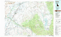
(9)- 1943 Map of Driggs, 1955 Print
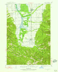 1943 Driggs1955 Print · USGSTeton Valley during the mid-forties is depicted as a thriving agricultural and rail corridor between the high peaks of the Teton Mountains. Researchers can trace the heritage of local rural life through labels for Bates Sch, Darby Ch, and the Union Pacific line.3 unique versions available
 - 1946 Map of Driggs
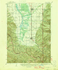 1946 Driggs1946 Print · USGSThe Teton Valley was a landscape of remote mountain peaks and irrigated ranch land during the mid-forties. Genealogists and historians can trace old homestead sites near Bates Sch and Sorensen or follow the historic Union Pacific rail line between Driggs and Victor.
 - 1955 Map of Driggs, 1967 Print
 1955 Driggs1967 Print · USGSEastern Idaho and Western Wyoming appear at a mid-century crossroads as the river valleys were fully settled and the high peaks protected. Genealogists and researchers can trace the rail towns of Rexburg and Driggs or follow the Snake River from Irwin to the Palisades Reservoir.3 unique versions available
 - 1958 Map of Driggs
 1958 Driggs1958 Print · USGSThe high Teton peaks and Snake River valleys are captured here in the mid-fifties, showing the region's agricultural and wilderness boundaries. Researchers can trace the Union Pacific rail corridor through Rexburg or locate early settlements like Clementsville and Tetonia.2 unique versions available
 - 1962 Map of Driggs
 1962 Driggs1962 Print · USGSThe Idaho-Wyoming borderlands are captured here in the early sixties, showing the peaks and valleys of the northern Rockies. Genealogists and historians can trace rail lines like the Union Pacific RR and isolated outposts like the National Elk Refuge or the Fort Hall Indian Reservation.
 - 1965 Map of Clawson, 1967 Print
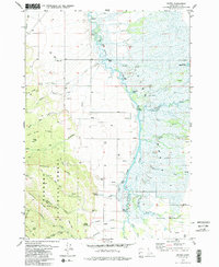
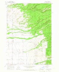 1965 Clawson1967 Print · USGSThe Teton Basin at the Idaho-Wyoming border shows a landscape of mountain ridges and intensive valley irrigation in the mid-1960s. Researchers can trace the complex water systems of the Center Canal and Hog Canal near the settlements of Clawson and Alta.3 unique versions available
 - 1978 Map of Driggs
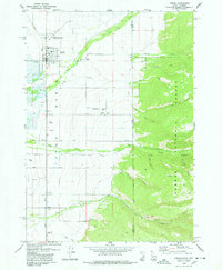 1978 Driggs1978 Print · USGSThe Teton Basin comes alive in the late seventies as a hub of rail, ranching, and mountain access. Genealogists and historians can trace the Union Pacific line through Driggs, find the Driggs-Darby Cem, or locate the old Drive-in Theater.2 unique versions available
 - 1979 Map of Bates, 1985 Print
 1979 Bates1985 Print · USGSTeton County in the late 1970s is characterized by the winding Teton River and the high ridges of the Targhee National Forest. Researchers can trace old family sites near Bates, locate the Cedron Cem, or follow the Long Ridge Trail into the mountains.2 unique versions available
 - 1988 Map of Rexburg, 1989 Print
 1988 Rexburg1989 Print · USGSThe Upper Snake River Valley in the late eighties shows a region shaped by water and agriculture. Genealogists and historians can locate family plots at the Rexburg Cemetery or trace the early paths of the Union Pacific Railroad through towns like Sugar City and Newdale.
End of results
Showing maps 1-9 of 9
Top cities near Driggs
Frequently asked questions
- What are the different types of historical maps available for Driggs?
- What is the oldest map of Driggs?
- Where can I purchase historical maps of Driggs for my home or office?
- Where can I download high-res historical maps of Driggs?
- Are there historical topographic maps available for Driggs?
- Is there historical aerial imagery available for Driggs?
- Where are historical maps of Driggs sourced from?