1900s (20th Century) Maps of Midvale, Idaho
Explore 7 historic maps of Midvale from the 1900s (20th Century). These maps offer a rare glimpse into what life looked like during the 1900s — showing old roads, neighborhoods, homes, and landmarks that have changed or disappeared over time.
Whether you're researching your family's past, planning a metal detecting trip, or studying how Midvale's landscape evolved across the 1900s, these high-resolution maps are a powerful tool for exploring the history of this region.
- Focus on a specific era: All maps on this page are from the 1900s, giving you a focused view of this time period.
- See what’s changed: Compare century-old streets, trails, and buildings to today's modern landscape using overlays and satellite layers.
- Research with precision: Use these maps for genealogy, historical research, land use analysis, or educational projects.
- View, download, or print: Maps are fully viewable online in high resolution, and can be downloaded or printed for your own records.
Start exploring Midvale's history through authentic maps from the 1900s. This is your window into the past.
Midvale, ID maps
(7)- 1953 Map of Mann Creek, 1955 Print
 1953 Mann Creek1955 Print · USGSThe agricultural valleys of Washington County come alive in this early 1950s survey of the river country near Weiser. Genealogists can trace a network of rural schoolhouses and landmarks including Saling Sch, Mann Creek Cem, and the Union Pacific Railroad.2 unique versions available
 - 1955 Map of Baker, 1964 Print
 1955 Baker1964 Print · USGSThe Oregon-Idaho borderlands are captured here in the mid-fifties as the Snake River underwent massive changes from dam construction. Trace the Oregon Trail Memorial Monument near Baker, find early mines like Virtue Mine, and follow the Union Pacific Railroad through Huntington.4 unique versions available
 - 1957 Map of Crane Creek Reservoir, 1958 Print
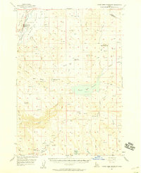 1957 Crane Creek Reservoir1958 Print · USGSThe Weiser River valley and its surrounding high-desert plateaus are captured here in the late fifties, showcasing a complex system of reservoirs and irrigation canals. Genealogists and historians can locate the Midvale townsite, the Midvale Cemetery, and rural landmarks like the Cozy Corners School (Aban'd).2 unique versions available
 - 1959 Map of Baker
 1959 Baker1959 Print · USGSThe Oregon and Idaho borderlands come alive in the late fifties, showing the rugged corridor along the Snake River and the high peaks of the Wallowa Mountains. Researchers can trace the legacy of the Union Pacific railroad or locate historic mining sites like the Flagstaff Mine and Virtue Mine.2 unique versions available
 - 1980 Map of Weiser, 1993 Print
 1980 Weiser1993 Print · USGSThe Snake River valley and the foothills of the Boise Mountains are captured here in the 1980s, showing the vital rail and water infrastructure of the region. Researchers can trace the Union Pacific line through Payette or locate rural landmarks like Hog Cove Butte and Wilburn Butte.
 - 1986 Map of Midvale
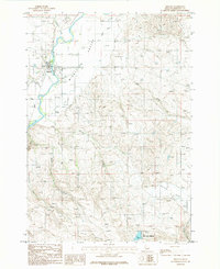 1986 Midvale1986 Print · USGSMidvale and the agricultural lands of Idaho's Middle Valley are captured here in the mid-1980s. Genealogists and local historians can trace family properties near the Cem or follow the waters of the Weiser River and Little Crane Creek Reservoir.
 - 1987 Map of Midvale Hill
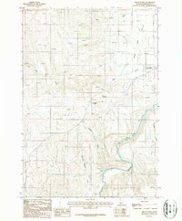 1987 Midvale Hill1987 Print · USGSWashington County in the 1980s shows a landscape shaped by the Weiser River and the Union Pacific railroad. Genealogists and historians can trace family-named landmarks like Keithly Creek and local hubs like the Lee Williams Memorial Airport.
End of results
Showing maps 1-7 of 7
Top cities near Midvale
Frequently asked questions
- What are the different types of historical maps available for Midvale?
- What is the oldest map of Midvale?
- Where can I purchase historical maps of Midvale for my home or office?
- Where can I download high-res historical maps of Midvale?
- Are there historical topographic maps available for Midvale?
- Is there historical aerial imagery available for Midvale?
- Where are historical maps of Midvale sourced from?